 |
|
||||||||
|
|
||||||||
van Binsbergen, W.M.J., 1993, ‘Making sense of urban space in Francistown, Botswana’, in: P.J.M. Nas, ed., Urban symbolism, Leiden: Brill, Studies in Human Societies, volume 8, pp. 184-228.
© 1993-2002 Wim van Binsbergen[i]
At least one third of the population of
Africa now lives in urban environments, and social scientists are
increasingly realizing that the zeal and competence with which
earlier generations of their profession have mapped the
ideological and symbolic universes of African villagers, now need
to be partly diverted to the urban scene. African towns have been
looked at as places where migrants from the rural areas settle,
accommodate to urban living, to each other (along such major
social-structural dimensions as ethnicity, class and religious
affiliation), to formal and informal sectors of a predominantly
capitalist economy, and to the state. Although it is more than
half a century since Wirth (1938) launched his seminal
distinction between urbanization (the process of becoming
urbanite) and urbanism (the state of being urbanite), and
since Hellman (1935) or Wilson (1942) first sought to explore
African towns as social settings in their own right, our
scholarly understanding of urban life-styles in Africa is still
rather limited. In the 1950s and 1960s the study of African towns
was in the forefront of Africanist anthropology, but this is no
longer the case. In recent decades, the emphasis on
‘development’ in the social-science approach to African towns
has often taken for granted that which needs most to be
explained: under what specific conditions and in what specific
forms do towns mediate between rural-based historic cultures on
the one hand, and on the other the post-colonial state (whose
overt pattern of organization is largely along bureaucratic lines
and whose ideology tends to be universalist), and a world-wide
economy (characterized by bureaucratic formal organization, mass
consumption, and proletarianization in the sense that urbanites
have become largely dependent upon wage labour).
Against this background it is inspiring and liberating to look,
as the editor of the present volume has invited us to do, at the
symbolism of Third-World towns. This perspective prompts us to
assess to what extent the contemporary urban environment has in
fact managed to produce and nurture symbols which selectively
refer to the state and the world economy, yet at the same time
negotiate dilemmas of rural-derived identity and of urban-rural
relations. It is here that one can begin to look for the stuff
that African urbanism is made of. Is it true to say that these
towns have engendered collective representations which are
strikingly urban, and which offer partial and tentative yet
creative solutions to such typically urban problems as incessant
personnel flow, ethnic, class and religious heterogeneity,
economic and political powerlessness, and the increasing
irrelevance, in the urban situation, of historic, rural-derived
forms of social organization (kinship, marriage,
‘traditional’ politics and ritual)? Mitchell’s Kalela
dance (1956) still offers a classic paradigm, stressing how
at the city boundaries elements of rural society and culture
(such as a rural-based ethnic identity, a minority language,
expressive forms of music and dance, specific ways to organize
production and reproduction in localized kin groups) may be
selectively admitted onto the urban scene, yet undergo such a
dramatic transformation of form, organization and function that
their urban manifestations must be understood by reference to the
urban situation alone. Or, in Gluckman’s (1960: 57) famous
words, ‘the African townsman is a townsman’ [iii]
Statements of this nature have helped to free our perception of
African urbanites from traditionalist and paternalistic
projections; for according to the latter they continued to be
viewed as temporarily displaced villagers whose true commitment
and identity continued to lie with their rural societies of
origin. The stress on the urban nature of African urbanites even
amounted to a radical political challenge, in a time when the
colonial (and South African) economy was largely based on the
over-exploitation[iv] of rural communities
through circulatory migration of male workers conveniently
defined as bachelors while in town. We can therefore forgive
these authors their one-sidedness, but there is no denying that
they failed to address the fundamental problems of meaning
which the construction of a town-based culture in the (by and
large) new cities of Africa has always posed.
African historic societies in the present millenium have
invariably displayed cleavages in terms of gender, age, class,
and political power, while containing only partially integrated
elements deriving from and still referring, beyond the local
society, to other cultural complexes which were often remote in
space and time. Yet they have offered to their members (and
largely in order to accommodate those very contradictions) a
fairly coherent universe, in which the human body-self,
interpersonal relations, the landscape and the supernatural all
featured in one composite, comprehensive world-view. In this
context, the meaning of an aspect of the local society and
culture consists in the fact that that element is perceived by
the participants, explicitly or implicitly, as belonging to that
general socio-cultural order, cognitively and emotively linked to
many other aspects of that order — a condition which produces a
sense of proper placement, connectivity and coherence,
recognition, identity as a person and as a group, aesthetics,
bodily comfort and even healing.
Such meaning is for a considerable part spatially expressed and
mediated, e.g. through the ground plans of dwellings, villages,
capitals, national territories, through the sacralisation of the
human space through shrines (including temples) and cemeteries,
and through the extent to which non-domesticized parts of the
landscape (the forest, hills, rivers) may take on diffuse sacred
connotations.
Generations of anthropologists, linguists, historians and
students of religion have monographically described and analyzed
these rural-based universes of African meaning, assessing their
variety and patterns of convergence, and tracing the ways in
which these universes have partially persisted, have been eroded,
eclipsed, or transformed as the case may be, under conditions of
political, economic and ideological incorporation in the wider
world. But what happens to meaning in town?
Fundamental as this question may be, we have to limit our scope
considerably, and specify our analytical tools accordingly, if we
are to address the specific theme of this symposium. We cannot
concentrate on those aspects of meaning which are enshrined in
the private, often invisible and ephemeral behaviour and
interaction of urbanites in their homes, private conversations,
private rituals. When we approach the topic of urban images from
the point of view of meaning, we have to look for such meaning
as is enshrined in publicly articulated collective
representations, and then particularly those which, through
their relative permanence, their anchorage in material forms of
buildings, roads, spatial arrangements, are mediated through and
at the same time constitute the townscape. We have to ask
ourselves under what conditions such materially-expressed
collective representations can at all be generated and
perpetuated in the relatively new setting of an African town,
whose fluid population (immensely heterogeneous when we look at
geographical and ethnic origins, languages, creeds, life-styles
and access to economic and political power) could rather be
expected to have myriads of fragmented and mutually contesting
parallel manifestations of meaning: the disconnected scraps of
many different rural life-worlds the migrants left behind when
becoming urban. It is particularly in the context of meaning that
we see African towns as the arena where a migrant’s specific,
disconnected and fragmented rural-based heritage is confronted
with a limited number of ‘cosmopolitan’ socio-cultural
complexes, each generating its own discourse and claiming its own
commitment from the people drawn into its orbit in exchange for
partial solutions of their problems of meaning.
Before discussing these complexes, it is useful to realize that,
as a source of meaning, the historic rural background culture of
urban migrants is not necessarily as fragmented as the
multiplicity of ethnic labels and linguistic practices in the
town may suggest. Ethnic groups have a history,[v] and
while the major ethnic identities featuring in and around
Francistown (Tswana, Kalanga, Ndebele, Barotse, Shona, Sarwa —
the Botswana term for San — etc.) can hardly be said to be
recent, colonial creations, underlying their unmistakable
differences there is in many cases a common substratum of
regional cultural similarities and even identities: continuities
such as a patrilineal kinship system, emphasis on cattle,
similarities in the marital system, the cult of the land and of
the ancestors, patterns of divination and of sacrifice, shared
ideas about causation including witchcraft beliefs, converging
ideas about conflict resolution and morality. The result is that
even urban migrants with a different ethnic, linguistic and
geographical background may yet find that they possess a cultural
lingua franca that allows them to share such historic
meanings as have not been mediated through the state and
capitalism. Sometimes specific routinized modes of inter-ethnic
discourse (such as joking relations) explicitly mediate this
joint substratum. Traditional cults and independent Christian
churches in town, which tend to be trans-ethnic, derive much of
their appeal from the way in which they articulate this historic
substratum and thus recapture meanings which no longer can be
communicated with through migrants’ direct identification with
any specific historic rural culture. Moreover, partly on the
basis or these rural continuities, urban migrants creatively
develop a new common idiom not only for language communication,
but also for the patterning of their everyday relationships,
their notions of propriety and neighbourliness, the
interpretation and settlement of their conflicts, and the
evaluation of their statuses.
After this qualification, let us sum up the principal
cosmopolitan complexes:
— The post-colonial state: a
principal actor in the struggle for control of the urban space; a
major agent of social control through its law-and-order
institutions (the judiciary, police, immigration department); a
major mediator of ‘cosmopolitan’ meaning through the
bureaucratically organized services it offers in such fields as
education, cosmopolitan medicine, housing, the restructuration of
kinship forms through statutory marriage etc.; a major context
for the creation of new, politically instrumental meaning in
the process of nation-building and elite legitimation; and
through its constitutional premisses the object (and often hub)
of modern political organizations.
— The capitalist mode of production,
largely structuring the urbanites’ economic participation and
hence their experience of time, space, causation, personhood and
social relations; involving them in relations of dependence and
exploitation whose ideological expression we have learned to
interpret in terms of alienation (the destruction of
historic meaning); but also, in the process, leading on to modern
organizational forms (e.g. trade unions) meant to counter the
powerlessness generated in that process; and finally producing
both the manufactured products on which mass consumption
as a world-wide economic and cultural expression — in other
words, as another, immensely potent form of ‘cosmopolitan’
meaning — depends, as well as the financial means to
participate in mass consumption.
— World religions, which pursue
organizational forms and ideological orientations rather
reminiscent of the post-colonial state and the capitalist mode of
production, yet tending to maintain, in time, space and
ideological content, sufficient distance from either complex to
have their own appeal on the urban population, offering formal
socio-ritual contexts in which imported cosmopolitan symbols can
be articulated and shared between urbanites, and in which —
more than in the former two complexes — rural-based historic
symbols can be mediated, particularly through independent
churches.
The three cosmopolitan complexes each have their unmistakable
manifestations in the townscape: in the form of specialized
buildings, plots, quarters specifically set aside for state or
industrial functions; and each offer both social organization and
meaning. However, these three cosmopolitan repertoires of meaning
differ considerably from the ideal-typical meaning enshrined in
the rural historic universe. Although all three are historically
related, they are present on the urban African scene as mutually
competitive, fragmented, optional, and more or less anomic or
even — when viewed from a competitive angle — absurd. Yet
together, as more or less elite expressions, they constitute a
realm of symbolic discourse that, however internally
contradictory, assumes dominance over the rural-orientated, local
and historic repertoires of meaning of African migrants and
workers. The ways in which the cosmopolitan and the local idioms
interact, are ill understood for several reasons. Those who, as
social scientists, are supposed to study these patterns of
interaction are, in their personal and professional lives,
partisans of cosmopolitan repertoires and are likely to be
identified as such by the other actors on the urban scene. Much
of the interaction between repertoires is evasive and combines
the assumption of rigid subordination with the practice of
creative challenge and tacit symbolic resistance in private
spheres of urban life where few representatives of the
cosmopolitan repertoires have access. And whereas anthropology
has developed great expertise in the handling of meaning in one
spatio-temporal context (e.g. rural African societies) whose
wholeness and integration it has tended to exaggerate, the
development of a sensitive approach to fragmented and incoherent
multiplicity of repertoires of meaning, each assaulted and
rendered more or less meaningless by the presence of the other,
had perhaps to wait till the advent of postmodernism as an
attempt to revolutionarize, or to explode, anthropology.[vi]
Our classic predecessors in African urban studies worked on the
assumption that the African urban situation was very highly
structured — by what they called the ‘colonial-industrial
complex’ imposing rigid segregation and class interests, by
voluntary associations, by networks.[vii] In
the contemporary world, such structure is becoming more and more
problematic, and the town, especially the African town, appears
as the postmodern social space par excellence. Our
greatest analytical problem here is that as a social space it
lacks the coherent and unified structure which could produce a
single, convincing repertoire of meaning ready for monographic
processing; but this is not merely an analytical problem — it
appears to sum up the essence of what urban life in Africa today
is about.[viii]
These ideas will lead us in this paper’s
attempt to make sense, i.e. to assess the problem of meaning, of
urban space in Francistown, N.E. Botswana, with 60,000 the second
largest town in the country, and since 1980 going through rapid
expansion. Originating in a White gold-mining settlement almost a
century ago (and therefore without any historical background in
the Tswana ward system which continues to organize, to some
extent, many other towns in the country), despite the decline of
mining in the 1910s Francistown developed into a major railhead,
distributive and industrial centre, and nodal point in the flow
of migrant labour all over Southern Africa. A segregated town
until Botswana’s Independence (1966), its basic spatial
organization has remained dominated by the state and capitalism,
and their personnel requirements. Squatter areas and
site-and-service areas (which have often replaced squatter areas
or perpetuated them in an upgraded form), as well as
fully-serviced housing estates, have meanwhile diversified the
old layout, accommodating an unceasing influx of people from all
over Botswana and surrounding countries, and have extended the
range of spatial expression of the population’s economic and
class differences.
Functional specialization, however striking and meaningful a
feature of any townscape, is not in itself to be equated with
urban symbolism. How can we distinguish between socio-economic
association, and symbolism, in the context of the analysis of
socially-articulated meaning in the urban space? For instance, in
Francistown the toponym ‘Minestone’ (‘Gem’), as the
designation of a high-status residential area, carries overtones
of prestige, conspicuous consumption, reference-group behaviour
orientated towards a dominant White category of people,
life-style and culture. In a way, the latter phrase summarizes
the social symbolism of the name Minestone. Yet such symbolism
appears to be more diffuse, less ‘properly symbolic’, than
e.g. tthe symbolism of the low, circular or semi-circular mud
fence,[ix] which we find in many
residential plots in Francistown as a reminiscence of the viable
rural order and of the enclosed-yet-accessible
patrilineally-recruited homestead as the epitome of that order.
An intermediate case between these extremes would perhaps be that
of the nicknaming of residential areas by reference to
international toponyms, e.g. in everyday Francistownian
conversation ‘Beyrouth’ is understood to be the large,
supposedly chaotic, violent and working-class squatment of
Somerset[x] West, while
‘London’ is the supposedly aspiring middle-class, orderly and
bourgeois site-and-service scheme of Somerset East Extension.
Much further reflection is needed on the theory of (urban)
symbolism.[xi] When it comes to the
sacralization of urban space I suppose some inspiration could be
derived from theoretical work on shrines, regional cults and
pilgrimage.[xii] Another
interesting question would then be to define the conditions for
the urban space and its symbolism, under the modern state and
capitalism, to have room for secular or civil shrines — in
other words, monuments.
One of the most characteristic features of Francistown has been
the relative absence of publicly articulated carriers of
cosmopolitan meaning in the townscape: it was, and (despite the
building boom since the late 1980s) largely still is, a town
without street names, statues, monuments, striking public
buildings, without spatially articulated public symbolism.
The White- and Indian-dominated two-street business centre with
its modern architecture of banks and shopping ‘malls’, the
new single-level civic centre, fast-food and video outlets,
during the day is invaded by African people who only
conditionally, awkwardly, for specific purposes of employment or
consumption, venture out of their distant housing, preferably
under elaborate protective clothing and make-up. The town’s
symbolic barrenness, even in the central district and certainly
outside it, conveys the message that, for many of its
inhabitants, it is merely a temporary and scarcely convenient
space where cosmopolitan meaning, however implied to be
dominant and inescapable, is seldom articulated, internalized, or
shared, is always problematic, and often rejected; at the same
time this state of affairs points, as we shall see, to
fundamental contradictions in the relation between the state,
capital and Christianity in the social formation of which
Francistown forms part.
In order to do justice to the fragmented and evasive nature of
urban symbolism in Francistown, we have to remain close to the
descriptive data and traverse the town in all directions, keenly
looking for clues. With some apology, I invite the reader on a
guided tour, hoping that in the end it will prove rewarding. It
is not my intention to write, in the following pages, a mere
travel guide to Francistown; but neither is it my habit to jump
to conclusions, even if in the anthropological study of symbolism
such is not uncommon practice.
Francistown[xiii]
can be reached by train (along the track which since the end of
the nineteenth century has linked South Africa to what is today
Zimbabwe, Zambia, Zaire and Angola), by airplane (already in the
1930s its airport played an important role in the transport of
labour migrants to and from the Witwatersrand, as recruited by
the WENELA[xiv] agency) and by road:
the excellent tar road across Botswana from Tlokweng at the South
African border bifurcates at Francistown, one fork leading to the
Zimbabwe border at c. 80 kilometres north of the town, the other
fork northwest-bound to Nata (180 km) and from there either to
Kasane-Kazangula-Zambia or to Maun, capital of northwestern
Botswana.
A number of striking features reveal themselves already on
approach.
The first feature is that Francistown is an urban island,
sharply cut out amidst the rural environment of Botswana’s
North East district, and separated from the nearest
(African-populated) villages by a broad (25 km) fringe of
large-scale farms and mining concessions. There is hardly a
peri-urban area with transitional patterns of land use and human
settlement. This is due to the fact that as from the late
nineteenth century, most of what is today Botswana’s North East
district has been held as freehold land by the Tati Company (and
its legal predecessors)[xv]. The mining
concessions and White-owned commercial farms have extended right
to the city boundary. Unmistakably urban squatter areas like the
sprawling Somerset West have been encroachments on Tati Company
land, and the town’s planned extension in southern direction
(Phase IV etc.) in the 1980s was dependent upon and constrained
by the extent to which Tati Company land could be acquired by the
Francistown Town Council. In the Francistown case, therefore, the
conceptual boundary between town and village is very much a
spatial reality. Maintaining urban-rural ties in this situation
always involves substantial travelling.
The absence of a peri-urban fringe has implications for the
ritual articulation between town and country: while sacrifices
reminiscent of the historic rural culture are being carried out
at the town’s handful of mediumistic sangoma lodges
(located at private residential plots)[xvi] and
at a few Independent churches, there is no market for domestic
animals in Francistown (one can scarcely buy a life chicken at
the vegetable market, and then only on Saturdays), and as a
result every urban sacrifice puts the patient or the latter’s
sponsor in jeopardy: it is no mean achievement for a townsman
without personal motor transport to extract a goat from the
distant countryside. However, like many other Francistownians the
leaders of sangoma lodges have their own footholds (in the
way of cattle posts) in the countryside of northeastern Botswana,
and it is not only for reasons of the availability of sacrificial
animals, but also for symbolic reasons of avoiding pollution,
alienness, sorcery and social disapproval, that certain rituals
(e.g. initiation of a novice into the Shumba cult, which
is greatly feared among urbanites)[xvii]
can only be performed in this rural environment.
As a result of the absence of a peri-urban fringe, also, there is
virtually no horticultural activity in Francistown, which further
reinforces the conceptual and symbolic opposition between town
and country. Very few people cultivate vegetables in their
private plot; many people, however, have gardens in their village
home or have a working relationship with close kinsmen who have.
The town council operates a farming scheme for the destitute at
the Tati river bank in Somerset East Extension, but its share in
the total consumption of vegetables in Francistown appears to be
negligible.
A second feature is Nyangabgwe Hill, which
towers massively over the sprawling town and whose tall military
communication pylon, lit with red signal lights at night, can be
seen from all over town. For the larger part, the steep hill is
uninhabited, although the southern slope has accommodated, since
the mid-1960s, the PWD (Public Works Department) squatter area
due to be demolished in 1989 but still there.
A third feature is the railway, which for almost a century now
has been Francistown’s vital artery. The original railway line[xviii] dissects the urban area from south to north,
and there is no place in town where one does not hear the
characteristic railway sounds by day and especially by night.
A fourth feature is Tati River, whose wide bedding ondulates
through the entire urban area, intersecting with main roads and
the railway and creating a sandy, shrub-fringed boundary between
residential areas. Like most rivers in Botswana, the Tati River
is far from perennial and in fact contains water only a few days
a year. Among its smaller tributaries in the urban area, the most
important is Inchwe River. Monarch area, for decades a sprawling
uncontrolled African mine-workers’ settlement to be demarcated
and upgraded around 1980, in terms of transport by motor roads
constitutes a virtual peninsula bounded by the Tati and Inchwe
rivers.
The fifth feature is the relative absence of vertical
architectural accents. Francistown has the familiar Southern
African ‘township’ appearance only too well known from
world-wide television broadcasting on the South African
revolution: rows and rows of tiny, sink-covered houses at ground
level, each standing in its own tiny plot, serviced by dusty,
often unpaved roads. Towards dusk the smell of charcoal and wood
stoves fills the air and the fading light is filtered through the
blanket of smoke extending over the entire town. In the most
recent years, the skyline of Francistown has developed
considerably. Until the late 1980s the only high-rising
architectural features were: the gigantic Dumela storage
elevators in the Industrial Site seven kilometres north of the
town, and the airport’s main military hangar, scarcely one
kilometre west of the town centre and adjacent to the residential
areas of Aerodrome, White City, Bluetown and Masemenyenga. Since,
impressive complexes have been added: the Botswana Meat
Corporation abattoir on the town’s southern entrance; the
massive Nyangabgwe Hospital; and in the town’s business centre
the colonial-style single-level stores and offices are now
rapidly being replaced by imposing, brick-and-glass architectural
wonders of two or more levels high, which also increasingly fill
the many open spaces that used to exist between the centre’s
grid of streets.
Francistown (cf. diagram 1) has a clearly
defined spatial structure, which largely derives from the
functional specialization of parts of the town in the colonial
period. The Tati River constituted the main social and
geographical boundary within the town: that between Whites, the
dominant elite in control of commerce, industry (particularly
mining) and the colonial state; and Africans, who only as
salaried workers could enter the formal-economy sphere of
Francistown, and for the rest depended for their upkeep in
town.on ties of co-residence, kinship, sexual and marital
relations, ethnic identification, and informal sector activities.
For as long as Francistown was racially segregated, it was
impossible for Africans to live east and north of the Tati River,
with the exception of the Monarch peninsula adjacent to Monarch
Mine. Moreover, few of those thousands of Africans who did live
in their allotted space across the Tati River, held any formal
title to their plots — the overwhelming majority were de
iure squatters. The main exception was White City, a
significant name in itself, evoking the Whites as a standard
reference group of the relatively well-to-do Africans living in
that residential area on a limited number of plots in freehold or
leasehold.

Diagram 1. The urban space of Francistown
Indian families were very limited in number before the recent
economic boom of the town which started with the termination of
the liberation war in Zimbabwe in 1980. People classified as
coloured would have their allotted residential area at Coloured
Stands (now Satellite South), more than two kilometres away from
the ‘Central Area’ of White business and residence.
East of the Tati and Inchwe rivers was the White reserve, the
‘real Francistown’, articulated into a few constituent parts,
which I shall describe one by one.
Government Camp. ‘Government
Camp’ lies in the northern part of the area enclosed by the
Tati River, Inchwe River, Nyangabgwe Hill, and the railway line.
Here were the professional and living quarters of the colonial
civil servants, such as the magistrate, medical and veterinary
officers, etc. It is here that the oldest permanent buildings of
Francistown are to be found, such as the old court house, which
later was incorporated in Francistown’s first hospital, the
Jubilee Hospital[xix]; the latter was
recently surpassed by the immensely impressive Nyangabgwe
Hospital, situated at the other end of the town centre. In order
to accommodate the labourers of mainly the Public Works
Department, and in recognition of the scarcity of housing in the
town, the PWD squatter area was allowed to develop at the edge of
Government Camp since the mid-1960s [xx]
Adjacent to Government Camp there are the state prison and the
BDF (Botswana Defence Force) barracks.[xxi] Due
west of the barracks is the Francistown stadium, which is not
only the lively scene of weekly football matches drawing a crowd
of thousands, but also packed to the brim at national festivals
(President’s Day, Independence Day), when local politicians
(especially those of the Botswana Democratic Party — BDP —,
which has ruled the country since Independence), dance troupes
and gymnastic teams from local schools, musical bands and even
the town’s sangoma lodges with their ecstatic dances,
offer a programme in which entertainment, political edification
and traditional culture intermingle in a most significant manner.
Near the BDF barracks, Government Camp also contains an old White
cemetery now gone into disuse. A number of current cemeteries are
dispersed among the outlying residential areas of Francistown,
but I must admit that I did not make a systematic study of them
as aspects of the use of urban space, as rudimentary shrines or
monuments.
Light Industrial Site. Adjacent to
Government Camp there is the Light Industrial Site, where
colonial-style stores, workshops and factories are increasingly
replaced by impressive modern architecture. It is here that a
large proportion of the employed population of Francistown earns
a living. Here the Labour Office is located, where the labour
disputes that occur in this town at an astronomic rate are
arbitrated, and the jobless register for employment. The area is
particularly the heart of the wholesale trade: Francistown
services not only the North East district, but the whole of
northern Botswana and in addition large sections of Zimbabwe and
Zambia; and any Francistownian who has managed to lay his hands
on a retail license or can mobilize alternative forms of access,
does his shopping in the several enormous wholesale
establishments situated in this area. Here we also find,
spatially isolated from the rest of town, the extensive Catholic
Mission, with a church building and a secondary school, with its
latin name appropriately hinting at status mobility through
education: Mater Spei, ‘Mother of Hope’. Tucked away
in a corner between Government Camp, the railway and the Light
Industrial Site are the Railway Quarters, whose architecture is
even more reminiscent of colonial conditions than that of
Government Camp: the railway workers are still accommodated in
tiny zinc imitations of African round huts, densely packed in
straight rows and without the slightest comfort, services or
privacy.
Area W. The southern part of the area
demarcated above is that of Area W, where around the now defunct
WENELA complex a site-and-service area of lower middle-class
aspirations has developed in the last decade.
Central Business District. Immediately
east of the railway line (with a slight extension to the west,
into the Light Industrial Site, via a foot bridge across the
railway) there is the Central Business District, situated along
two parallel streets — Haskins Street, which borders on the
railway and halfway of which we find Francistown Railway Station,
and Blue Jacket Street, one block to the east.
The railway station contains the only conspicuous monument
Francistown can boast: on the platform bordering on Haskins
Street, enclosed in a high wire fence, and at the dead end of a
stretch of track apparently laid down for the sole purpose of
creating this secular shrine, we see an old locomotive, ritually
displayed as if to remind us that it is to the railway that
Francistown has owed its continued life. Being the real thing
rather than its image, it is scarcely convincing as a monument.
Also other transport functions are located in the Central
Business District. The town’s main taxi rank is along Haskins
Street immediately south of the railway station; from here one
can board line taxis to most residential areas and to surrounding
villages. The bus station is half a kilometre away, in the
southwestern corner of the district.
Streets and side-streets in this old core part of town are very
wide, according to van Waarden (1986) in order to allow a
sixteen-oxen span to turn without difficulty. There is an
intricate system of back alleys: sanitation lanes now gone
obsolete, through which also the African workers could get to
their places of employment. I would not be surprised if African
customers, too, were expected to gain access to the shops through
these alleys.
Haskins Street, named after a local trading dynasty nearly as old
as Francistown itself,[xxii] used to be the
principal shopping street, and it is here that we find the retail
outlets of old patronized by Africans. The major ones are still
owned by the Haskins company and the Tati Company, and still in
the familiar colonial-style buildings which dominate the entire
street. Along Haskins Street we also find the two now somewhat
disreputable hotels whose various bars, along with a few other
such establishments concentrated in this same district, play a
major part in Francistown social life: the Tati Hotel and the
Central Hotel.
The restructuring of the town road plan and the building boom of
the 1980s have however caused Blue Jacket Street (named after a
local gold mine) to surpass Haskins Street, and it is here that
the powers of capitalism are more emphatically visualized:
shopping arcades and malls, video outlets, fast-food outlets,
supermarkets, and oversized buildings (completed since 1989)
housing Barclays Bank, the Tati Company Office, Air Botswana,
chique clothes’ and sports shops. Here is also, in a building
owned by Francistown mayor Mr. Ebrahim (a Motswana of Indian
ancestry, born in Ramokgwebana, 80 km north of Francistown on the
Zimbabwe border, and a member of the town’s other major trading
family beside the Haskins’s), a superbly finished spacious
cinema, as well as a fully-stocked electrical appliances shop.
Along Blue Jacket Street we also find the pride of Francistown
Town Council, the new (but single-storey) Town Council offices in
red brick, whose H-shaped ground-plan encloses an ornamental
garden from the Blue Jacket Street side, and a spacious car park
from the back; the figure ‘20’, reproduced nearly man-high in
the garden in angular, computer-type white letters, reminds us
that this nice and modest civic centre, completed in 1986, was
the fruit of twenty years of Independence. It was also the fruit
of an opposition municipal regime which soon after the completion
of the building was supplanted by a ruling-party one. Adjacent to
the roundabout which gives access to Blue Jacket Street from the
south, there is the luxurious Thapama Lodge Hotel, the obvious
choice for the many civil servants and industrialists passing
through booming Francistown.
However, the general revamping process now going on has not yet
extended to some of the most significant buildings along Blue
Jacket Street: the Magistrate’s Court and adjacent local
government offices still look very much like they did thirty or
forty years ago.
One block away from the civic centre is the vegetable market, a
few of whose stalls are occupied by electronic repair shops and
seamstresses. In the midst of the Central Business District’s
proud insistence on White-dominated world-wide mass consumption
and enterprise, the vegetable market under a few shady jacaranda
trees is the most stereotypically ‘African’ place of
Francistown, where hardly any Whites come to shop and where the
‘colourful’ display of vegetables, the preparation and
consumption of African meals (a staple of maize porridge with
meat relish) in the back of the market, and the loud music
blasting away from radios and stereos already repaired,
constitute an enclave of uncomplicated absence of inhibition
amidst the intimidating display of White symbolic and economic
dominance elsewhere in this part of town.
Throughout the Central Business District, moreover, the streets
are lined with peddler’s businesses. Many vendors operate from
stalls whose framework remains overnight; others squat on the
pavement and display their goods on spread-out pieces of cloth.
Items for sale vary from food (fat cakes and cooked mealies,
particularly), via cloth and clothing, to cheap watches and
jewelry, cosmetics, ladies’ bags, wallets and other
indispensable items of accomplished urban life. With the
exception of prepared food[xxiii] all items for sale
in the peddlers’ circuit have been manufactured, and imported
from either South Africa or the Far East. Articles of local
manufacture, e.g. household implements including baskets, are
rare in Francistown; if available, they are distributed not so
much through peddling but by such large-scale manufacturers and
sellers of curios as BGI and Bushman Products in the Light
Industrial Site, and then the more likely buyers are not Africans
but Whites. Sometimes these items are peddled at the vegetable
market. The main other place where African artefacts are being
sold in the streets is in the car park in front of
Francistown’s Spar supermarket — the sellers are Zimbabwean
Africans, the buyers Whites.
In addition to the peddlers, there are a few cobblers and
seamstresses working on the pavement, for their own account and
independently from the commercial firms in front of whose shops
they have found hospitality. Their customers are invariably
African. Most people in the streets and in the shops are African,
anyway. If Whites (and African elites) are less conspicuous on
the sidewalks, it is because these are the people with motor
cars, and although the town centre is small enough to park
one’s car somewhere and do one’s shopping on foot, this is
not what one prefers, for combined reasons of social status, the
risk of theft from cars, and the insistence on social distance
across class and racial lines.
Even in the large supermarkets whose assortment (imported lock,
stock and barrel from South Africa with which Botswana entertains
a customs union) specifically caters for White/elite tastes and
budgets. Yet, although their shopping baskets often contain only
one or a few items, more and more African customers now find
their way from the ‘traditional’ retail outlets along Haskins
Street (with their austere shop interiors and their crude
security regulations against African shop-lifting, but also with
their assortment carefully attuned to African taste and
experience, and by and large slightly lower prices) to the fancy,
less strictly policed and occasionally cheaper supermarkets like
OK, Spar and Fairways. In fact, many small peddlers of food and
groceries in the outlying residential areas do their
‘wholesale’ purchases at these supermarkets rather than at
the wholesalers in the Light Industrial Site — for the latter
they tend to lack the time, transport facilities, license, and
(since real wholesale purchases have to be in bulk) the money.
The African non-elite presence in the old core of Francistown and
particularly the Central Business District touches on fundamental
issues in the use and signification of space in this town. We
shall come back to this important point after completing our tour
of the town centre.
Central area. Immediately to the
northeast of the Central Business District there is the old White
residential area (‘Central Area’), with spacious plots
containing houses ranging from decent to luxurious. With the
Central Business District, this is the only part of town where
streets have formal names displayed on street signs. Most of
these names derive from obscure White characters in the early
decades of the town, or from early Bechuanaland history in
general: Guy Street, Feitelberg Street, etc. The important thing
about these street names is that they are very few, and that no
African Francistownian would ever use them nor know to which
street or which historical personage they refer. This aspect of
the urban symbolism of Francistown is only meaningful to the
local Whites.
Interesting is the location of the University of Botswana’s
local institute for adult education on the very corner of
Lobengula Avenue and Khama III Avenue — of course, a century
ago Tati district itself could become a mineral concession, a
focal point of peripheral-capitalist expansion in mining and
agriculture, and hence the cradle of Francistown, because it
constituted more or less a no-man’s land between the Ndebele
king Lobengula’s and the Ngwato king Khama III’s territories.
In this area we also find Francistown’s John Mackenzie and
Clifton[xxiv] primary schools
catering for the (predominantly White) local elite.
As an expression of White concepts of urban space, the Central
Area is also the only part of town where two small parks can be
found, as well as a public swimming pool. However, their
constituting formal public spaces in an elitist though
post-segregation area makes these amenities pose a dilemma
typical of Francistown today: since these places are open to
working-class Africans they are no longer visited by
Whites/elites (who have access to secluded alternatives at the
Thapama and Marang hotels, the Francistown club and private
houses), and while African youths massively patronize the
municipal swimming pool, the parks tend to be empty as a sign of
latent contestation.
Area M, Area I, Area A. South of the
‘Central Area’ more recent residential areas have developed,
which in terms of class association are however rather continuous
with the White and elitist connotations of the Central Area.
Minestone is the most prestigious residential area in
Francistown, apart from the larger and older (and almost
exclusively White-occupied) Tati Riverside plots on both sides of
the Tati river.
We have noted the emphatic presence of
African working-class people in Francistown’s Central Business
District.
To irreverently paraphrase Gluckman, African customers are
customers, and local commerce has understood that it does pay to
keep social and security thresholds sufficiently low for
potential patrons from the African working class to cross them.
In this respect Francistown might give one the illusion of an
effectively desegregated society. All facilities in the Central
Business District are of course in principle open to anyone
regardless of race or social class.
In fact however, the standard image of Furnivall’s (1944)
plural society (however discredited the concept is from a
theoretical perspective, and however obsolete in a
well-functioning post-colonial society like Botswana’s) would
meet the social reality of Francistown better: the presence of
well-defined social classes, with large differences in political
and economic power, whose membership badges tend to feature
somatic characteristics such as skin colour along with such
acquired status symbols as style of dress, mode of transportation
and language use, and who meet (and rather uneasily at that) in
the reserved social space of the marketplace only.
‘Marketplace’ should then not even be taken literally (Whites
in Francistown shun the vegetable market, the peddling circuit
and such market-like retail outlets as are found at the bus
station, Jubilee hospital, and in the outlying residential areas)
but be understood as ‘formal outlets of commodity
distribution’. And just as non-elite Africans risk to be
relegated to the status of trespassers and potential burglars
whenever they seek to enter the elitist residential plots of
Minestone and along the Tati River, so there are still many
situations in the Central Business District where the White
uniform of colour, and/or the elitist uniform of smart dress, are
a requirement for entry or at least for decent service; Thapama
Lodge is a case in point, and so are most company offices and,
somewhat further away from the town centre, the premisses of the
Francistown Club;[xxv] Clifton School; or
the Marang Hotel which caters almost exclusively for a White
clientele directly from, or at least orientated towards, South
Africa.
Alternatively, there is a marked sense of uneasiness (generally
covered under excessive politeness, which occasionally may give
way to downright hostility) when Whites try to break through the
invisible boundary which lies over even the Central Business
District of Francistown (and anywhere else in that town), and
when they venture afoot in the streets, the bus station, the
vegetable market, the sanitation alleys, the peddlers’ circuit,
the non-elitist drinking places of the town centre.
Working-class Africans on the one hand, and Whites/African
elites on the other, make a fundamentally different use of
Francistown’s central space and attach a fundamentally
different meaning to it.
The Whites/African elites own it, are competent in the complex
socio-economic procedures, varieties and choices of commodities
offered there, and for them the architectural and planological
designs, the rare street names, the manner of display and the
assortment in the shops, patterns of commercial etiquette,
reinforce their sense of identity and security as a dominant
class; and by their means of transportation and their choice of
venue they limit to a minimum the extent to which they should be
required to rub shoulders with working-class Africans.
The subjective townscape of the White Francistownians still does
not greatly differ from that of the many South African tourists
passing through on their way to the distant game reserves of the
Chobe and the Okavango Rivers: ‘a few decent shops (their own
familiar OK, Spar and Fairways!) and filling stations along a
major through-road (Blue Jacket Street), a few passable garages
on the other side of the railway in the Light Industrial Site, an
excellent camping and curio shop in between (BGI), a nice,
White-frequented hotel and camping site at adequate distance from
the shops (Marang Hotel), and as a backdrop to these essentials,
barely registering onto consciousness, ‘‘the African
location’’ ’ (more than 50,000 people!).
Alternatively, African working-class people, although far more
conspicuous than Whites and African elites in the streets of the
Francistown town centre, know only too well that they do not own
the place. They are aware of invisible thresholds of
incompetence, embarrassment, suspicion and lack of spending power
when they venture from the streets into the shops except for
those few shops known to cater explicitly (albeit in a
humiliating way) for the African clientele. When they enter the
buildings of the Central Business District (and the same would
apply for the Light Industrial Site and the elitist residential
plots) it is far more likely that they do so as wage labourers
(or as would-be wage labourers asking for a job) than as
respected clients. Their apparent appropriation of the public
space of the streets, as pedestrians, as eaters of fast food, as
peddlers and their clients, as people on their way to and from
work, school, hospital, church, shops and government offices, may
subconsciously seek to express an aspiration of ownership as a
reflection of political ideals in an independent and economically
thriving Botswana, but in reality is more a form of ‘being cast
out into the streets’ — the streets being the one public
space which they know cannot be denied to them, not even in the
centre of Francistown which for hundreds of kilometres around is
the focal point of White and capitalist domination of African
life.
The contestation of public space along lines of class and colour,
and as a result the emergence of parallel, scarcely intersecting
patterns of use of the urban space, is not limited to
Francistown’s Central Business District. If for a moment we
look at the town not so much as a residential space but as a
network of formal road communications within and across material
boundaries such as the railway line, the Tati River and the
Inchwe river, and fenced plots, it is very revealing that
Africans (who, as we have seen, are the town’s typical
pedestrians) use the formal road system only selectively and
negotiate the main boundaries in a manner very different from
White/elite motorists. The African pedestrians insist on
shortcuts across the formal road system, use the railway track
and the sandy river beds[xxvi] as just another
obvious passage which can be utilized at whatever convenient
point rather than as a boundary which can only be negotiated at
formal bridges and crossings. In fact the spontaneous footpaths
quite often lead through plot fences, whose wiring is casually
lifted in the process, or trampled underfoot. A case in point is
the Francistown Club golf course, which is used, simultaneously
and virtually without mutual recognition of each other’s
presence, by two different sets of people: paid-up members using
the terrain for its intended purpose, and numerous working-class
pedestrians taking short-cuts across the terrain.
In other words, the map of urban transportation of African
pedestrians is not the same as that of White/elite motorists —
it refers to a different town altogether.
The division of the urban space in terms of class and
colour is merely one aspect of the major cleavage dividing
Francistown society. Its effects are far from limited to the use
and conceptualization of space, but amount to a
compartmentalization of life worlds and symbolic universes. In
addition to the private domain which each African family, or each
White and Indian family for that matter, in Francistown
negotiates in the face of other such families within their own
category, there is a kind of ‘collective private’ domain on
either side of the class boundary, where the common knowledge on
one side of the boundary becomes a carefully guarded secret on
the other side. The Mwali cult,[xxvii]
sangoma-hood, the significance of rivers and hills,
therapeutic participation in Independent churches, are
considered private if collective African matters which are
virtually impossible to articulate in conversations and
interactions across the boundary. As a White, operating from a
house I had rented for my family in the non-elite
site-and-service area of Somerset East Extension, becoming aware
of that boundary and desperately looking for means to cross it
dominated my participatory research for the better part of a year
(van Binsbergen 1991b).
Although this imperceptible boundary, as we have seen, is an
interactional and a conceptual one much more than a geographical
one, Francistown’s old town centre is very much perceived, by
the African population, as outside their own collective private
world, as inimical and alien. ‘Going to town’, therefore, in
other words leaving the residential space of the outlying
townships and entering the Central Business District, the Light
Industrial Site, or Government Camp, is strongly felt to be the
crossing of a boundary, which requires significant and costly
rites of passage, whose main purpose is self-protective. No
matter how informal one’s attire when around the house (where
many women go barefoot, with a wrapper as their principal
garment, and occasionally exposing the breasts; men have matching
forms of informal residential dress, featuring e.g. sleeveless
undervests, patched-up trousers and shoes with holes) it is
virtually inconceivable to enter ‘town’ without having washed
one’s entire body, having put on freshly washed and ironed
clothing, preferably of a kind local Whites would consider to be
in the range of ‘over-dressing’, or without decent shoes, or
on a bicycle instead of in a taxi or (if at all unavoidable) on
foot. Perfumes, other cosmetics, and protective African medicine
help to ease one across the apparently massive and intimidating
boundary. It is a continuous source of amazement to see perfectly
spic-and-span townsmen emerge, as a matter of course, from the
most humble and dilapidated dwelling houses, and one can only
admire their skill in keeping up these standards even when their
journey leads across several kilometres of muddy road on a rainy
day. It is possible to explain away some of these precautions as
strategic in the lively local market of occupational and amorous
success, and in the struggle for peer group esteem; but we are
dealing with a strictly observed institution here, not with mere
individual strategies. On the one hand this over-preparation is
defensive reference-group behaviour, an expression of insecurity
lest one be found out to be a mere working-class or peasant
African in a White- and elite-dominated town; on the other hand
there is, after all these preparations, a sense of
self-assertion, of exorcising such humiliation as one has
internalized, and of claiming a right to the central urban space
by adopting its appropriate uniform — after the rite of passage
one hopes to become a legitimate if only temporary member. The
striking point remains that these painstaking preparations are
made not just for a full day’s work at the office or factory or
for major shopping; I have known people to go through the entire
routine just for the purpose of buying a few litres of paraffin
at the Haskins filling station on Blue Jacket Street.
So far some basic characteristics of
Francistown’s core area, dominated by the state, capitalism and
White culture — the latter particularly in the form of formal
bureaucratic organization and mass consumption, and characterized
by a peculiar, invisible boundary of class and (to a considerable
extent still) race. Let us now turn to the outlying areas of the
town.
We have seen how in the era of segregation the residential space
reserved for the African population was located west of the Tati
and Inchwe rivers, where moreover they rarely held title to the
land they occupied but were squatters. In other words, prior to
Independence the African population of Francistown was largely a
population of squatters. Squatments eventually even developed
east of the rivers: PWD, Satellite and particularly Somerset
East, all of which seem to pre-date Independence by at least a
few years.
Various strategies were adopted to improve the housing situation,
reduce the insecurity and crowding in the existing African
residential space, and accommodate the massive influx of urban
migrants from all over the country, both as a result of
commercial, industrial and governmental expansion, and as a
result of the declining rural economy under conditions of
drought, rural class formation and over-grazing. The first
official attempts to formalize squatters’ occupancy status in
Francistown go back to the late 1960s.[xxviii]
Subsequently, existing squatter areas (such as Monarch, Bluetown,
Riverside North, Tatitown, Tati West, Riverside South, a section
of Somerset West, and Block 2) were upgraded: plots were
demarcated (typically at considerably larger size — ideally 400
m2 — than the units which squatters had appropriated
spontaneously or had managed to maintain in the face of continued
influx of migrants), and those persons and household units
considered to be too many were given priority as candidate
occupants of newly designed site-and-service areas which came to
form a wide circle around Francistown’s older core: the
residential areas of Area S, Aerodrome, Area W, Somerset East
Extension, Donga, Block 7, and Area L, among others. With the
exception of these ‘victims of thinning’,[xxix]
the site-and-service plots were reserved for Francistownians with
a regular monetary income not exceeding P3,000 per annum.[xxx] Their exclusive use rights to the plot were
defined by a formal ‘Certificate of Rights’ (framed, this
document constitutes a standard ornament on the walls of
Francistown houses in site-and-service areas), they qualified for
a low-interest building loan, and were required to pay a service
levy of P8.50 per month. Despite inevitable misuse it can be said
(van Binsbergen 1989a) that it was by and large the target
population which benefited by the SHHA scheme, and thousands of
plots have been distributed on its basis.[xxxi]
All demarcated plots in fully-serviced, site-and-service and
upgraded residential areas in Francistown lie immediately on a
formal road which is supposed to be regularly maintained by the
Town Council, and which features on the maps of the department
for Town and Regional Planning. Yet none of these many streets
has a name (a state of affairs sometimes deplored in the local
freely-distributed advertisement paper, the Northern
Advertiser), and people can only describe their own address
in these areas by reference to a four- or five-digit plot number
(which is seldom displayed anyway) or to far from unique local
landmarks, such as the area’s vending stalls, a bend in the
road, etc. In this use of plot numbers and the absence of any
higher-level shared designation at the street or neighbourhood
level, we may see an almost caricaturish expression of the
‘atomisation’ of urban life under conditions of capitalism
and the modern state. At the same time it points to the absence
of a shared discourse of reference and meaning between planners
and their clients, the town dwellers.[xxxii]
SHHA houses have to be built against strict specifications (whose
observance is frequently inspected and constitutes a condition
for the building loan to be made available), but the occupant has
a wide choice of alternatives, from the simplest two-room house
to accomplished two-bathroom villas. Here the only uniformity is
a demarcated plot of 400 m2, with metal markers on the corners,
and a dug latrine pit covered by a slab — on which the occupant
has to erect a standard-type toilet building. The Botswana
Housing Corporation, alternatively, has erected hundreds of
serviced houses in each of the three categories of low, medium
and high cost. Their architecture is standardized and cannot be
influenced by the occupant.
These three planning strategies of upgrading, site-and-service
schemes and fully-serviced housing, in the face of increased
influx proved insufficient to prevent squatting, as an unplanned,
people’s fourth strategy. The town’s residential areas with
their four strategies of structuring and occupying the urban
space constitute a laboratory where the central theme of this
paper and of our symposium is tested out in various experiments.
The results of the experiments in the four situations, however,
are difficult to compare with each other since in each situation
the occupants’ freedom to structure the private urban space is
substantially different.
By definition, this freedom is maximum in the case of the
squatments. It would be a fallacy to expect urbanites to use this
freedom exclusively to implement rural, ‘traditional’
patterns in their use of the urban space. The squatter’s
appropriation of land in the urban fringe does not particularly
emulate a perennial rural pattern any more. State control
(through the Land Boards) over rural land in Botswana has greatly
altered patterns of rural occupancy in the course of the
twentieth century (cf. Werbner 1970, 1982). One should not
entertain too romantic an idea about the structuring of space in
contemporary Botswana villages: in their outlying parts
considerable room and a degree of unboundedness may still
prevail, but in village centres residential plots are often
directly adjacent to each other; with their standard size of
1,600 m2 (40x40 m) they are only four times larger than urban
SHHA plots; they tend to have wire fences; neighbours are often
non-kin; and problems of privacy, annoyance, theft, moral
indignation, religious rejection, absence of effective social
control and witchcraft suspicion occur between rural neighbours
much in the same way now as they do in town. In one respect
squatters are better off than villagers: there is no obvious,
rural, ‘traditional’ equivalent for the possibility of
converting squatting into formal occupancy rights, such as occurs
in Francistown (and other Botswana towns) whenever squatments are
upgraded or removed.[xxxiii]
And again, when similarities emerge in people’s spatial
responses in these four situations, this may be not by their own
choice but as an effect of the converging planological measures
and considerations of civil servants. Thus, all plots in
fully-serviced, site-and-service, and upgraded residential areas
are to be situated on a public access road however humble; this
does not particularly reflect people’s reluctance to share
their private space with their neighbours in case the latter have
no direct access to the road, but mainly represents a
bureaucratic conception of the ideal urban space.
Squatments, outside official control, provide a testing ground
for people’s minimal conceptions of urban privacy, and here
there is considerable variation: from the relatively spacious
plots, demarcated by a low row of stones or a single-wire fence,
in many squatments, to — under conditions of extreme
overcrowding, in PWD — dwellings which (although independently
occupied by occupants who are not mutually related) are
back-to-back and sometimes even without proper access to the foot
paths. These developments are adaptations to urban conditions.
With a similar degree of optionality, however, rural continuities
occur at the same time, for instance in the relative lack of
insistence on specific toilet facilities; in the adornment of
house walls with pictorial patterns in mud of a contrasting
colour; the construction of a low mud fence within which cooking
and social conversation may take place; or the attempt to
surround oneself with kinsmen and more in general with people
from one’s home village as urban neighbours (cf. diagram 2).
The latter strategy, so marked in PWD, is only feasible in
squatments (with possible traces in upgraded squatments) since
individualized bureaucratic procedures determine plot allocation
in site-and-service and fully-serviced areas.

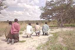
diagram 2. Clusters of fellow-villagers in
the PWD squatter area, Francistown, April 1989.[xxxiv]
Such continuities are more than the mere nostalgic and pathetic
return to familiar, rural patterns: they are an attempt to render
the urban residential space meaningful by structuring it in terms
of a shared, ancestral world-view. Such attempts will have to
remain selective: actors are only partially, through
socialization, language use and continued urban-rural ties,
participating in their rural background, and — largely
surrounded by non-kin strangers anyway — for the rest have to
survive, at the same time, in an urban life-world dominated by
White culture, the state and capitalism. Among African
Francistownians today, there is considerable variation in
rural-urban ties and continued rural investment. Francistown, in
other words, does not always play the same role in the process of
social reproduction of its inhabitants. A useful idea of
modes-of-production analysis[xxxv] is that, to the
extent to which people remain dependent upon non-capitalist,
rural-based modes of production, and hence remain involved in
urban-rural ties if they are townsmen, to that extent (and in
those situations involving such ties) will they continue to
subscribe to the ideological components of these non-capitalist
modes of production. What is the range of variation of such
involvement?
There is certainly the characteristic Botswana pattern[xxxvi] of people who, as individual members of
extended families involved in long-term economic and social
strategies, straddle the urban-rural divide, invest on the one
hand in cattle and a rural base, — in education, a
formal-sector career, and an urban base, on the other. I am still
analyzing my quantitative data on Francistown, but I estimate
that this group would account for nearly 50% of adults in
Francistown, both men and women. In these cases people’s
dealing with the urban space could be characterized as
‘reticent use’ rather than as ‘eager appropriation’. In
their social reproduction, the town’s role is more or less
balanced against that of the village and the cattle post. Their
urban house is looked upon as mainly a sensible investment and is
readily let to tenants even if it offers levels of comfort and
status appeal exceeding such alternative accommodation as the
landlord will have to use when in town. When people in this
category use the town house themselves (it is often the scene of
an endless procession of rural kin and tenants, each staying only
for a relatively short period), it is largely left unadorned. No
time or money is wasted on an ornamental garden, and the interior
contains the bare minimum and (as will be appreciated by anyone
who has seen women try and prepare food in the rain and wind in a
kitchen-less urban plot) often offers less comfort than a village
house would. Under such conditions, the town house is appreciated
for its utilitarian rather than its symbolic or status value. It
is in this context that we must view squatters’ stoic
acceptance — which has little to do with poverty, since others
in the same income bracket do opt for modest modcomfs— of low
levels of comfort (absence of a toilet, bathroom and kitchen;
small rooms; absence of outdoor space). From this point of view
it can also be understood why many non-squatters lack enthusiasm
for a nice yard embellished with flowers, rendered more private
by wire fencing, shrubs or a tall brick fence, and more
impressive by fancy brickwork and a hand-carved front-door. For
the people in this category, the urban space is experienced
primarily in pragmatic terms: the town is an environment
where one can make money, go to hospital, send one’s children
to a good school — identity, and the valourisation of the
living space by historic symbols imbued with profound meaning,
are concerns reserved for the village. Their town house does not
look like a home, and in fact home is emphatically elsewhere.
In this category of town-dwellers balancing their urban and rural
commitment, women, meanwhile, are in a slightly different
position from men, since the burden of reproduction (childbirth
and particularly bringing up the children) is more or less
exclusively falling on them as female head of households and
unmarried mothers;[xxxvii] and while such
patterning of their reproductive roles would not in the least
stigmatize them nor jeopardize their taking part in long-term
extended-family strategies, they will often find that they have
to fence for themselves and their children. Women have a fair
(probably even advantaged) access to the Francistown job market,
but mainly in the lowest paid jobs. Women also get a fair deal
from the housing department, as statistical analysis has shown
(van Binsbergen 1989a). Considering a woman’s difficulty of
looking after her rural economic interests single-handed, and
taking into account that for women (in view of their lion’s
share of reproductive and productive labour under austere rural
conditions) urban living is even more attractive than it is for
men, we see adult women (i.e. mothers) in Francistown insist
somewhat more on the acquisition and development of urban housing
than men of the same age and background. But in the case of
women, too, the town house means an asset in a long-term survival
strategy, much more than a requisite for modern status
achievement.
Around this prevailing balanced position minority responses exist
on both sides:
— On the one hand the unsuccessful urban
migrant who does not manage to adopt a viable utilitarian
attitude towards the town, and spends a period in town either as
a co-resident kinsman with a more committed urbanite; as an
independent squatter; or as a passing tenant in a squatter area.
These characteristics would particularly apply to the Sarwa
squatters among the population of the most devastated and
miserable squatment of Francistown, Masemenyenga. For people in
this category, the town does not yet play a major role in their
social reproduction, even if the viability of their rural
alternatives has greatly declined.
— On the other hand those whose rural ties
are rather weaker than average (because they are
second-generation townsmen, or in the process of upward social
mobility with a secure source of income from capitalism or the
state, because of family conflicts, of the declining viability of
the Botswana rural economy, etc.), for whom the town is the main
locus of social reproduction, and who have developed a sense of
urban identity,. The latter is usually combined with a desire to
acquire the status symbols of modern urban living: wardrobe,
dresser, display board, lounge suite, television set, other
consumer electronics, gas stove etc. Their house does look like a
modern home, and advertisements, furnishers’ and mail-order
catalogues are spelled to keep informed of fashionable trends and
affordable offers. For people in this category the house is not
just a utilitarian asset, but a central means of self-expression
— a material structure, still, but one charged with meanings
derived from the ‘modern’ i.e. cosmopolitan, domains of life.
There is of course a minimum financial requirement here: even
with widely available (but intimidating and humiliating)
hire-purchase facilities such as are offered by the large
furniture shops in Francistown’s Central Business District, one
needs to have a regular if moderate income to qualify. Yet it is
amazing to see how people manage, over the years, to accumulate
consumer goods with the kind of minimum formal-sector income that
still falls within the SHHA limits. For the people in this
category, building itself (with all the implications of
artisan’s skills, knowledge of building materials and their
prices, the necessity of gaining access to transport facilities
and of organizing labour) becomes a self-expression and a
passion, by which one asserts one’s aspirations and one’s
determination to join the urban rat race. In this category one
really deals with the urban space with a sense of appropriation,
and by doing so adopts and internalizes such meanings as the
state (the main distributor of building plots) and capitalism
have to divulge. Such investment presupposes security of
occupancy, and people in this category would rarely direct their
building and decorating energies at a squatter plot — if
starting out from such a plot because of sheer housing shortage,
they would seize every opportunity to more for a more secure plot
and reserve their investments for the latter.
With regard to the bureaucratic,
planological structuring of the outlying residential areas (with
the exception of un-upgraded squatments, of course) one finds a
number of recurrent patterns. All residential areas have their
area of vending stalls, more or less solid structures of
corrugated iron where groceries and vegetables are offered for
sale at slightly higher prices than in the town centre but with
attractive credit facilities; access to one of these stall
depends on possession of a vending license, and is thus largely
controlled by the municipal authorities. Similarly, all
residential areas have what is called a ‘Freedom Square’ —
in most new or upgraded residential areas this is in fact the
only street-name people use and recognize for a particular part
of their area. It is here that the councillor (member of the city
council) responsible for the ward in which the residential area
finds itself[xxxviii] addresses his
constituency, and where the several political parties on the
Botswana scene take turns to canvas their prospective voters.
Thus the residential area is rudimentarily articulated by its
economic and political central places, and there conveys a
(limited) degree of meaning within the context of the
post-colonial state and capitalism, highlighting differences in
political and economic power between inhabitants of the
residential area, and suggesting possible reference groups and
strategies for status advancement.
Central places at the level of the residential area or
neighbourhood may, moreover, include a neighbourhood school, the
local SHHA office, an urban clinic, a bottle store around which
customers may gather and sip their canned beer, a beer garden
retailing Chibuku (a manufactured imitation of African
home-brew) and any number of private — but perfectly legal — shebeens
where a variety of drinks (including home brews) is offered for
sale. The condensation of social interaction occurring around
these central places in general fails to generate a sense of
community at the residential-area level. In the absence of
community centres the residential area’s several churches would
have a role to play here, but in the denominationally and
therapeutically fragmented society of Francistown (most
independent churches offer healing as well as salvation) they do
so mainly for their own members and sympathisers. The minimum
neighbourly participation in life crises such as marriage and
death; the low level of neighbourly social control and hence
frequent recourse to formal, geographically and socially distant
law-and-order agencies such as the police and the urban customary
court for conflict regulation; the ineffectiveness of the ward
councillor to mediate in major conflicts; the invisibility and
often non-existence of the ward development committee and other
politically-affiliated bodies at the residential-area level —
all this suggests (cf. van Binsbergen 1991a) social life in
Francistown’s residential areas to be dispersed and
individualized. It is meaningless from the perspective of
a historic, rural cosmology, and at the same time derives but a
shade of meaning from the three cosmopolitan repertoires of
meaning and organization.[xxxix]
Architectural structures which dominate the
townscape are those associated with the state and capitalism.
This means that in Francistown only an inconspicuous role is
reserved for one category of structures which in European and
American towns is so visually dominant: churches. Imposing church
halls and spires which tower over a town’s main throughways and
squares — this sort of thing is entirely absent in Francistown.
The only church to be found in the old town centre, at the
boundary between the Central Business District and the Central
Area, is the Anglican St Patrick’s Church, a brick structure
whose modest dimensions and miniature spire reminds one of a
village chapel in England; the back street on which it is
situated, behind the civic centre, is named ‘St Patrick
Street’, and this is virtually the only case of a Francistown
street-name having religious (and thus universalist)
connotations.
The only other church building which stands out near the town
centre is the large, Zimbabwean-orientated Apostolic (Vapostori)
Church on the main road passing Area W going to the Tati River.
Several major cosmopolitan church missions, such as the Catholic
Mission and the Seventh Day Adventist Mission, are located
outside the African residential space and form little enclaves on
their own. The outlying residential areas contain scores of
church buildings. Some of them are of rather elaborate modern
brick architecture,[xl] but a far greater
number is built on a self-help basis, in an architecture scarcely
standing out among the surrounding houses, and displaying
considerable reticence in self-advertisement: no sign, or a small
hand-painted one.[xli] Churches may attain
a certain conspicuity at the residential-area level, but they are
far from a marked presence in the townscape as a whole.
Basangoma (spirit mediums) and baprofiti (‘prophets’,
i.e. leaders of African Independent churches) are the African
Francistownian community’s principal specialists in the
articulation and manipulation of meaning. They are the only ones
to actually sacralize the urban space in its own right through
the creation of shrines and the staging of ritual and sacrifice
in the urban context. It is true that the sangoma shrines
to a considerable extent evoke a viable rural social and
cosmological order revolving on ancestors;[xlii]
but at the same time items charged with cosmopolitan meaning (the
lodge leader’s relatively luxurious town house, modern
furniture, emphasis on cash and on cash-bought paraphernalia and
sacrifices, reliance on manufactured food and drink, even the
ubiquitous plastic shopping bags) are far from shunned, and they
are sacralized in the ritual process continuously going on at the
sangoma lodges. The baprofiti’s position is
related but somewhat different: their reference is to the
cosmopolitan repertoires of meaning much more than to the
historic rural repertoire, and they impose severe limitations
upon the selection from the modern society that their adherents
are allowed to indulge in, yet they too offer ritual and symbolic
ways in which the suffering and temptation engendered in that
modern world can be alleviated and a person can return to it
without being overwhelmed by it — ways which make that world
once again an inhabitable place. In this way the baprofiti,
too, sacralize and to some extent rehabilitate the urban space
itself. Both types of ritual specialists offer a way out from the
alienation which for most other Africans in Francistown is both
an accepted fact and a major factor in their strictly utilitarian
approach to the town as intrinsically devoid of (historic, rural)
meaning, as anything but home.
At this juncture, we should mention Richard Werbner’s (1985,
1989) perceptive attempt to define aspects of the symbolism of
African Independent churches in Zimbabwe and North East Botswana
by reference to two axes: personhood, which he argues can be
either framed or unframed, and space, which can be either bounded
or unbounded. In this way he is able to pin-point specific
differences in church idiom, and also to construe these
differences as elements in an ‘argument of images’ which
essentially addresses the dilemmas of displacement, movement and
alienation in the context of migrancy, urbanization and an eroded
rural cosmology and economy. Werbner’s approach certainly
illuminates the specific form certain Independent church
buildings take — as well as the absence of such buildings in
other cases — but his post-structuralist abstraction from
concrete social forms and situations renders it less applicable
in the present context.[xliii] Nor does
Werbner’s interpretation exhaust the spatial symbolism at hand
in the African Independent churches. His static insistence on
doctrine and architecture fails to capture the spatial and bodily
dynamics of group interaction. In many Independent
churches this takes the form of a dancing chorus, a circular
dancing movement, or even a ‘planetary’ movement with the
dancers (as detached, impersonal ‘atoms’, once again?)
turning both around their own axis and, jointly, around a common
centre, where often the congregation’s newborn children,
novices, baptismal candidates, sufferers or sick are placed as if
to have maximum benefit from the energy unleashed by the frantic
yet carefully orchestrated movement of the congregation. Here,
and in the not unrelated sangoma dancing ritual, we can
see the (attempt of a) group-wise appropriation and hence
transformation of a small ritual space inside town, as an active
way of confronting and exorcising the alienation which is
paramount in the everyday living experience of the African
workers in the urban space outside the ritual situation.[xliv]
Sometimes this ritual appropriation is of an amazing directness.
For instance, in the Francistown Morningstar church which I
studied in detail, the nocturnal dancing worship would take place
in a barely roofed shelter of corrugated iron, in Somerset West,
immediately adjacent to the railway line. The congregation’s
planetary dance would be accompanied (as is often the case in
ecstatic ritual, wherever in the world) by respiratory exercises,
here meant to release the Holy Spirit. It took the form of a
concerted loud hissing which, combined with the stamping of feet
and the rustling of ceremonial robes, was strikingly reminiscent
of a stream locomotive. Towards midnight, the increasing outside
noise and the beam of a headlight penetrating into the
dilapidated church building would announce an approaching train,
the trembling of the floor under the impact of the dancers would
increase by the vibrations of the train passing, and the two
sounds, so strangely alike, would merge into a cacophonic yet
eloquent statement about images of space, movement and meaning in
a Southern African railway town. Yet on the conscious level I
seem to have been the only one to notice, among those present —
even though forms of spirit possession imitating locomotives have
been endemic in South Central Africa throughout the twentieth
century.
The basangoma and baprofiti also specifically
mediate between rural spatial symbolism and that in town.
I have already explained how the town’s river beds, in the
African pedestrians’ perceptions, are convenient passage-ways
rather than boundaries. This is the place to point out that in
the symbolism of the urban landscape they feature also in other
capacities. The rivers (whose connotations of liminality may be
obvious) have retained their historic rural symbolism as the
abode of the ancestors, of territorial spirits and of the Great
Water Serpent — even if they are dry most of the time. The
urban rivers play an important part in the ritual of the town’s
sangoma lodges in that every novice has to be chased
across one of them, dropping sacrificial coins and being beaten
by the senior lodge members. Lodge members ritually wash their
bodies outdoors in the thicket adjacent to the stream, on the
occasion of initiation and bereavement. The rivers also play a
role in the baptismal rites of the Independent churches, whose
symbolism is historically African at least as much as it is
biblical.
Hills are in a category akin to rivers. Nyangabgwe Hill does not
only visually dominate the town. The etymology of this place-name
contains virtually the only bit of shared historic collective
consciousness among the local population: many Francistownians
can tell you that the name derives from the Kalanga words for
‘rock’ and ‘to stalk’, and offer the nutshell myth of a
hunter mistaking a rock for a prey he thought to be stalking.
This hill is only the tallest of a system of about ten hills
around the confluence of the Tati and Inchwe Rivers, and on the
tops of several of these hills there are archaeological sites,
with zimbabwe-type fishbone-pattern brickwork revealing
these places to have been residences of regional minor rulers
incorporated in a powerful state (closely associated with the
Mwali cult and the Kalanga language) encompassing much of
northwestern Botswana and Zimbabwe until only a few centuries
ago.[xlv] The contemporary
ethnic consciousness of the Kalanga in and around Francistown
lacks awareness of this glorious historical past and concentrates
on their humiliation at the hands of the Ngwato (a Tswana
sub-group) mainly in the colonial period. I suppose that in the
technical legal sense these archaeological sites are national
monuments, but in the sociological sense they are certainly not,
since very few Francistownians are aware of their presence and
significance. The hills do however feature in the ritual of the
(mutually closely related) Mwali and sangoma cults and in
that of the, somewhat more distantly related, African Independent
churches, as places of theophany comparable with the rivers.
Exhausted by our guided tour of Francistown,
let us withdraw from descriptive detail and seek to complete, on
a more abstract note, our task of making sense of urban space in
Francistown.
At first, when thinking about my contribution to the present
symposium, my leading idea was: ‘how is it possible for an
urban migrant to live in a place which has no meaning’.
Gradually, however, I came to appreciate that capitalism, the
state, and Christianity also are major complexes creating,
organizing and upholding meaning, and that the real problem of
social life in Francistown is not the absence of meaning, but the
fragmented, incoherent, alienated, mutually contested and
contradictory nature of the various repertoires of meaning (all
of them projected onto the urban space) seeking to capture the
Francistownian’s mind and actions.
I have already stressed a number of factors in the light of which
this pattern can begin to be understood:
— the heritage of residential segregation
between African and White population segments in the town;
— in the past and to a large extent (if we
substitute ‘White and African elite’ for ‘White’) at
present, the above factor is itself a manifestation of these two
segments’ different power positions within the capitalist mode
of production and the colonial, subsequently post-colonial state.
Francistown, although a thriving town in a eminently successful
independent African country, yet displays patterns of class and
racial contestation of the urban space that one would associate
rather with conditions of White minority rule in the Southern
African sub-continent. Because of its history of mining, monopoly
capitalism and land alienation by the Tati Company, Francistown
and the North East district are more reminiscent of South Africa
than any other part of Botswana, whose benevolent Protectorate
rule in general did not lead to conspicuous White presence nor
oppression.
But this basic structure, which would apply in most African towns
in the colonial period, does not really explain the peculiarities
which, to my mind, make Francistown rather unique. Other factors
would add more specificity:
— The role of this town as a railway head
and as a shunting point in the international transfer of labour
migrants between their rural homes and their place of work on the
South African Witwatersrand. Francistown and the surrounding
villages have absorbed large numbers of stranded male labour
migrants from Zambia, Malawi and Zimbabwe. Therefore Francistown
society has been less continuous with the surrounding countryside
than might have been the case if it had been exclusively
populated from there.
— The continued partial reliance, on the
other hand, on rural, and partly non-capitalist, modes of
production pursued outside town, makes for a relative lack of
insistence on the signification of the urban space among those
many Francistownians who feel that their ‘home’ (as the hub
of their meaningful universe) is elsewhere anyway. One can afford
to live in a town without street-names, monuments or other
publicly articulated symbolism, if one has an eminently more
meaningful social space elsewhere.
— Therefore there is a continued
projection of a diffuse rural spatial symbolism onto the rivers,
hills, and (e.g. in the the low mud fence, the sangoma
lodges, the symbolism of African Independent churches) the
residential plots of the town.
— The point about these ‘traditional’
(i.e. non-capitalist, non-statal, non-White) elements in the
town, however, is not so much that they are there, but that they
have not been negotiated to become conspicuous elements in the
publicly and centrally constructed symbolism of the urban space.
They are to a considerable extent underground, tacitly
acknowledged and utilized by the African population as major
components of their ‘collective private’ domain, but never
articulated in the latter’s interaction with powerful
representatives of the state and of capitalism: civil servants
and employers. They help to constitute the invisible but
virtually impenetrable spatial and conceptual boundary which
divides Francistown society, even despite the superficial
appearance of both Whites and African elites, and African
working-class migrants, as being increasingly united in a
relentless pursuit of mass consumption and the other spoils of an
economically viable more or less democratic post-colonial state.
The discovery of a ‘collective private’ symbolic domain —
full of historic rural references — among African working-class
urbanites, virtually inaccessible for Whites/elites, should not
make us close our eyes for the extent to which the urban space is
symbolically structured by the internal dynamics within and
between the three cosmopolitan repertoires: the state, capitalism
and Christianity. The interpretation of elements of meaning in
the Francistown urban space should include an analysis of the
principal contradictions and power blocks within Botswana
society. Without aiming at an exhaustive discussion, let us try
to highlight significant aspects by a number of strategic
questions.
Why is it that (in the face of the boom, especially in the
most recent years, of prestigious architecture associated with
commerce and industry) even in the quarter of a century since
Independence, the Botswana state has been rather reticent to
leave its imprint on the local townscape? The new civic
centre is small-and-beautiful, most of the other offices of the
central and municipal administration are bleak colonial-type
structures failing to appeal to the imagination, and so is —
tucked away in the Light Industrial Site across the railway line
— the office of the ruling party. And the Tatitown urban
customary court, one of the two main outlets of a (totally
routinized and police-dominated) version of customary law in
Francistown, was until recently crammed into the few square
metres of a circular zinc temporary shelter! The main exception
is formed by the military, a rising but still reasonably
well-contained force within the Botswana constitutional
democracy. The signal lights and the pylon on Nyangabgwe Hill,
and the air-force hangar, loom large over the townscape, but
their utilitarian form can hardly be said to be inspired by the
desire to display state power.
Part of the answer seems to lie in the increasing disjuncture, in
the Francistown context, of capital and the state. Although both
cosmopolitan complexes represent a departure from local
tradition, they can no longer be treated as the obvious allies
they were in the colonial period. Then the White element pervaded
both, whereas now we see only the most entrenched non-African
local elites (the Haskins’s, the Ebrahim’s) bother to
penetrate the Botswana state (as BDP politicians, Speaker of the
National Assembly, Mayor of Francistown), whereas the building
and industrial boom has relegated the White category in town to a
position of power which the state is eager to please rather than
to control or co-opt. The very paucity of monuments of
Francistown also largely stems from this disjuncture: as a White
creation, the obvious thing for Francistown Whites before 1966
would have been — like happened in Zimbabwe in the 1950s-1970s
— to raise reminiscences of the colonial and mining past to
monument status. However, in modern times it is the state rather
than a town council or an ethnic group which defines, erects and
protects monuments as a legal category, and after Independence
the Tswana-dominated state of Botswana has seen little reason to
raise the oldest colonial buildings and other vestiges of the
White-dominated founding period to monument status. Despite its
Tswana name (which means ‘Display Culture’!), White elements
prevail in the Supa Ngwao Museum, a small Francistown
middle-class voluntary association[xlvi]
seeking to promote cultural activities and dreaming of a
Francistown local museum, to imitate the success of the Serowe
Museum. The latter has been rather successful, but it presented
an obvious case: situated in the traditional capital of the
dominant Ngwatoland region (the home of King Khama III, Regent
Tshekedi, and the first BDP President and State President Sir
Seretse Khama), and even housed in Khama III’s state villa.
There is no national political reason to invest in White
monuments in Francistown, and moreover, due to its colonial and
post-colonial history of Kalanga, anti-Tswana identity, there is
every reason for the state to limit the monumental repertoire of
Francistown to a few brass plaques in the facades of prestigious
buildings, commemorating their being among the blessings of the
central government and their having been opened by a senior
government official.
This brings us to the ethnic dimension[xlvii]
in the articulation of meaning in the Francistown urban space. Why,
with the general trend of Africanizing colonial place-names, has
it proved impossible to substitute ‘Nyangabgwe’ for
‘Francistown’ — even if the former name is already
colloquially used? The region in which Francistown arose has for
centuries been mainly occupied by Kalanga speakers, with
minorities of speakers of Tswana, Ndebele and San. Because of
far-reaching land alienation by the Tati Company, and the
town’s peculiar history of migrancy which made Kalanga women
(catering for international migrants) rather more conspicuous in
town than Kalanga men, the Kalanga failed to articulate
themselves as the typical ‘host tribe’, and Kalanga was never
the town’s lingua franca. After Independence many
Tswana-speakers from all over Botswana came to swell the ranks of
the urban African population, and Tswana hegemony consolidated
itself within the state and the ruling party. However, it was in
Francistown that Botswana first major and enduring political
party (Botswana People’s Party, BPP) was founded in 1960 (by P.
Matante, K.T. Motsetse and M. Mpho), and (like other
Francistown-based opposition parties gradually to emerge) it
strongly appealed to Kalanga ethnic and linguistic sentiments.[xlviii] During the first twenty years, Francistown was
a BPP stronghold, and largely in control of the Town Council and
the Mayorship. The Tswana centre’s strategies of populist
co-optation and avoidance of open conflict, in addition to the
largely locally-confined resources of a BPP municipal
administration now supplanted by a BDP one, explain both the
reticence of state manifestations in the townscape, and the
failure to articulate unmistakable expressions of Kalanga ethnic
identity on the public scene of Francistown.
Beside White associations and Kalanga-Tswana ethnic conflict,
there is another aspect to the relative reticence of the state in
the articulation of the Francistown urban space. Despite its
inevitable shortcomings,[xlix] Botswana is a
functioning democracy. Populism has been one of the strategies of
the ruling, Tswana-dominated elite to gain the kind of
grassroots-level support that has gained the country
international admiration. The prevailing model of socio-political
order revolves around consensus, consultation and participation,
much more than around state oppression and obtrusive
manifestations of state hegemony. In this respect the Botswana
state is really a remarkable exception to the pattern most
African post-colonial states have displayed in the 1970s and
1980s. Such an orientation of the state does not tally with an
intimidating state presence in the townscape through
megalomaniacal architecture. The BDP elite’s conservative
conception of Botswana as a largely rural, pastoral, peaceful
society in which towns are almost undesirable blemishes scarcely
eligible for state subsidy, implies that any fundamental cleavage
or contradiction between state and civil society is denied: the
state is almost considered a large-scale village, and its
subjects, as Batswana, are supposed to share in that imaginary
village’s neo-traditional values and thus stick together. An
emphatic state presence at the local urban scene through
intimidating buildings would be incompatible with that ideology.
In this respect it is very instructive that the most impressive
and massive recent building the state has erected near the town
centre of Francistown had to be a hospital: the new Nyangabgwe
Hospital which reminds the population that state power is
benevolent and coincides with their own self-interest. A peaceful
struggle attended the naming of this building: Kalanga activists
insisted that the hospital should be named after Kalanga and BPP
politician Matante who died in 1979 [check]; shunning the
ethnic and party-political divisiveness implied in such a name a
compromise was reached by giving the superb building the Kalanga
name of the hill which dominates Francistown — but after which
it could not yet be renamed itself.
Meanwhile this emphasis on state aloofness[l] also
means that the state has far from realized its full potential to
mediate such contradictions as exist within the civil society,
and particularly, to limit White and capitalist dominance; hence
its inability, more than twenty years after Independence, to
erase the invisible boundary that runs through the system of
urban meaning, perception and interaction. A greater input of
unifying symbolic engineering on the part of the state might have
done Francistown a lot of good. The state’s reticence is partly
responsible for the relative absence of publicly articulated
carriers of meaning, which makes Francistown such a bleak place.
All this suggests that, ultimately, ‘making sense of urban
space in Francistown’ — the interpretation of patterns and
contradictions of meaning as expressed in the urban space —
consists in highlighting the struggles, on the part of the state
and capital, to control both each other and civil society,
including such vital ideological expressions as represent
repertoires of meaning which are independent from and cannot be
reduced to, the logic of the populist state, wage labour and mass
consumption. A continued reliance on historic, rural forms is one
such repertoire, and its main strategy turns out to go
underground, to make itself invisible in the urban space except
for those who already know. Kalanga ethnicity constitutes a
closely related repertoire of meaning, and as I am arguing
elsewhere (van Binsbergen, in press) it has great difficulty of
articulating itself in the face of Tswana linguistic, cultural
and political hegemony, and of the rewards the latter offers to
those who accept to be Kalanga only in their inner rooms, while
publicly submitting to Tswana dominance.
Christianity is another such repertoire. Why is St Patrick’s
street a short back-street, and are churches (even
cosmopolitan, main-line ones) so inconspicuous in the
townscape, despite the fact that the number of Francistown
urban Christian congregations would be somewhere between sixty
and a hundred? African Independency is in terms of numbers of
adherents, number of congregations, and the variety of services
offered to the population (including therapy and social
belonging) by far the major Christian expression in Francistown.
For obvious reasons the links between Independent churches and
the White-dominated capitalist complex are limited. Independent
churches’ strategies vis-a-vis the state vary between
accommodation and submission on the one hand, and on the
other strategic evasion in the appropriate awareness of the
churches’ own hold on civil society (van Binsbergen 1990b).
Here again the townscape (characterized by the aloofness of both
state and churches at the overall level of the town as a whole)
confirms the dilemmas of power and meaning existing in the local
and national society. In this context, moreover, Francistown
occupies a peculiar place: along with the surrounding North East
(formerly Tati) district, it formed a White-controlled refuge for
Independency[li] while, during most
of the colonial period, elsewhere in the Bechuanaland
Protectorate the chiefs, far from having their powers eroded by
the colonial administration, could selectively favour specific
cosmopolitan church missions.
Finally, there is one major aspect of the creation of meaning in
Francistown which for reasons of space and economy of argument
has regrettably to remain outside our present scope: the
mediation of cosmopolitan, increasingly global images of
identification and evaluation through modern electronic media,
literacy, and formal education. The pursuit of education, not
only for children and adolescents but also for adults in night
classes, Bible courses and on-the-job training, is a major
activity in Francistown, and no longer one confined to an
intellectual or economic elite. The state, capitalism and world
religions are each conspicuous in this domain, as agencies
organizing and financing formal education,[lii]
offering contexts in which formal education is a key to status
advancement and power, and structuring this domain increasingly
in the direction of commoditification — of market forces and
commercialization. The impact of these complexes on the
articulation of meaning in Francistown’s urban space is
considerable, but while my data do extend into this domain, I
cannot go into a specific analysis here.
When I returned to Francistown for
additional field-work in April-May 1992, I found the process of
naming the town’s streets and putting up street signs to be
suddenly in full swing. The Francistown Town Council’s attempt
to involve the local population in the naming has led to a few
names being rejected and a few popular suggestions being adopted.
Yet the overwhelming emphasis on street names that are non-local,
non-Kalanga, and conceptually alien (like a number of street
names evoking Ngwaketse regiments — only meaningful to Batswana
from Kanye district in the south of Botswana; or street names
referring to the English or Latin names of plant species and to
English names for astronomic constellations) by and large support
my argument, which has stressed the absence of publicly
articulated carriers of meaning in Francistown. Regrettably I
must reserve a fuller analysis of the new Francistown street
names for another occasion. Further field-work prompted by having
written the present paper also opened my eyes to the
conceptualization of the intimate and personal space in the
village situation, and to the considerable continuities that
exist in this respect between village and town; I regret, again,
that it is impossible to incorporate this insight in the present
paper already gone to print.
Beach,
D.N., 1980, The Shona and Zimbabwe, 900-1850, Gwelo: Mambo
Press.
Chirenje,
J. M., 1977, A history of Northern Botswana 1850-1910,
London: Rutherford.
Chretien,
J.-P., & G. Prunier, red., 1989, Les ethnies ont une
histoire, Paris: Karthala/Agence de Cooperation Culturelle et
Technique.
Cooper,
D., 1980, ‘How urban workers in Botswana manage their cattle
and lands’, National Migration Study Working Paper 4, Gaborone:
Central Statistical Office.
Cooper,
D., 1982, ‘An overview of the Botswana urban class struggle and
its articulation with the rural structure: Insights from
Selebi-Phikwe’, in: Hitchcock & Smith 1982: 245-54.
Daneel,
M.L., 1970, The God of the Matopo Hills — An essay on the
Mwari cult in Rhodesia, The Hague/Paris: Mouton for African
Studies Centre.
Egner,
E.B., 1971, ‘Interim report of the Tati settlement project,
Francistown’, Francistown: s.n.
Epstein,
A.L., 1958, Politics in an urban African community,
Manchester: Manchester University Press.
Epstein,
A.L., 1967, ‘Urbanization and social change in Africa’, Current
Anthropology, 8, 4: 275-95.
Feddema,
H., 1987, Overleven door samenleven: Naledi, een armenwijk in
Botswana, Amsterdam: VU [Free University] Uitgeverij.
Furnivall,
J.S., 1944, Netherlands India: A study of plural economy,
Cambridge: Cambridge University Press.
Gerold-Scheepers,
T.J.F.A. & W.M.J. van Binsbergen, 1978, ‘Marxist and
non-marxist approaches to migration in Africa’, in: W.M.J. van
Binsbergen & H.A. Meilink, Migration and the
transformation of modern African society, African Perspectives
1978/1, Leiden: African Studies Centre, pp. 21-35.
Geuijen,
K., 1992, ‘Postmodernisme in de antropologie’, Antropologische
Verkenningen, 11,1:17-36.
Gluckman,
M., 1945, ‘Seven-year research plan of the Rhodes-Livingstone
Institute of Social Studies in British Central Africa’, Rhodes-Livingstone
Journal, 4: 1-32.
Gluckman,
M., 1960, ‘Tribalism in modern British Central Africa’, Cahiers
d’Etudes Africaines, 1: 55-70.
Hellman,
E., 1935, Rooiyard: A sociological survey of an urban native
slum yard, M.A. thesis, University of Witwatersrand;
reprinted, Rhodes-Livingstone Paper No. 13, London: Oxford
University Press for Rhodes-Livingstone Institute; reprinted,
Manchester: Manchester University Press for Institute for Social
Research, 1969.
Hitchcock,
R.R., and M.R. Smith, (eds), 1982, Settlement in Botswana,
Gaborone: Botswana Society.
Holm,
J., & P. Molutsi, 1989, eds, Democracy in Botswana,
Gaborone: Macmillan.
Kapferer,
B., 1988, ‘The anthropologist as hero — Three exponents of
post-modernist anthropology’, Critique of Anthropology,
8, 2: 77-104.
Kerven,
C., 1976, ‘Migration and adaptation to Francistown, N.E.
Botswana’, Botswana Notes and Records, 8: 301-302.
Kerven,
C., 1982, ‘Rural-urban interdependence and agricultural
development’, in: Hitchcock & Smith 1982: 234-244.
Krijnen,
E., 1991, ‘PWD: Een squatterwijk tusen staat, stad en
platteland: Verslag van een onderzoek in Francistown,
Botswana’, M.A. thesis, societal history, Erasmus University
Rotterdam.
Kwelegano,
C.M.T., 1978, ‘The history of Francistown to the 1960s’, B.A.
thesis, Department of History, University of Botswana.
Lagerwerf,
L., 1982, ‘They pray for you...’’: Independent
churches and women in Botswana, Leiden: Interuniversity
Institute for Missiological and Ecumenical Research (IIMO), 1982.
Lesholo,
J.M.O., 1982, ‘The new towns of Botswana’, in: Hitchcock
& Smith 1982: 293-302.
Masale,
G., 1985, ‘Ethnicity and regionalism in Botswana and their
impact on elections: A case study of the North-East and
Francistown’, paper presented at the workshop on preliminary
results from 1984 election study project at the University of
Botswana, Gaborone, 16th to 19th May 1985.
Meillassoux,
C., 1975, Femmes, greniers et capitaux, Paris: Maspero.
Mitchell,
J.C., 1956, The Kalela dance: Aspects of social relationships
among urban Africans in Northern Rhodesia, Manchester:
Manchester University Press.
Mitchell,
J.C., ed., 1969, Social networks in urban situations,
Manchester: Manchester University Press.
Molamu,
L.L., 1989, First draft report on Francistown Phase IV
development area study, Gaborone: Applied Research Unit,
Ministry of Local Government and Lands.
Molokomme,
A.L., 1991, ‘Children of the fence’: The maintenance of
extra-marital children under law and practice in Botswana,
Leiden: African Studies Centre.
Morton,
F., & J. Ramsay, (eds), The birth of Botswana: A history
of the Bechuanaland Protectorate from 1910 to 1966, Gaborone:
Longman.
Murray,
A., H. Nengwekhulu, & J. Ramsay, 1987, ‘The formation of
political parties’, in: Morton & Ramsay 1987: 172-186.
Nas,
P.J.M., 1992, ‘Jakarta, city full of symbols: An essay in
symbolic ecology’, paper read at the symposium ‘Urban images:
Cities and symbols; symbols and cities’, Leiden, January 1992;
revised version in the present volume.
Nencel,
L., & P.Pels,. eds., 1991, Constructing knowledge:
Authority and critique in social science, London: Sage.
Nengwekhulu,
H.R., 1979, ‘Some findings on the origins of political parties
in Botswana’, Pula, 1, 2: 47-76.
Picard,
L.A., 1987, The politics of development in Botswana: A model
for success?, Boulder & London: Lynne Rienner Publishers.
Ramsay,
J., 1987, ‘Resistance from subordinate groups: Babirwa,
BaKgatla Mmanaana and BaKalanga Nswazwi’, in: Morton &
Ramsay 1987: 64-81.
Republic
of Botswana, 1974, A social and economic survey in three
peri-urban areas in Botswana, Gaborone: Central Statistics
Office.
Republic
of Botswana, 1983, Guide to the villages and towns of
Botswana: 1981 population and housing census, Gaborone:
Central Statistics Office.
Republic
of Botswana, 1984, Francistown development plan: Report of
Survey, s.l.
Republic
of Botswana, 1986, Report of the Francistown Planning Area
Committee, Ministry of Local Government and Lands, s.l.
Schapera,
I., 1943, ‘The native land problem in the Tati district’,
unpublished report to the Bechuanaland Protectorate Government
(cf. Schapera 1971).
Schapera,
I., 1971, ‘Native land problems in the Tati district’, Botswana
Notes and Records, 3, 219-268.
Tapela,
H.M., 1976, ‘The Tati district of Botswana, 1866-1969’, Ph.D.
thesis, University of Sussex.
Tapela,
H.M., 1982, ‘Movement and settlement in the Tati region: A
historical survey’, in: Hitchcock & Smith 1982: 174-188.
Tlou,
T., & A. Campbell, 1984, History of Botswana,
Gaborone: Macmillan.
Tshambani,
M.M.W., 1979, ‘The Vapostori of Francistown; the study of an
African independent church from 1951 to the present’, B.A.
thesis, Department of History, University of Botswana.
Tyler,
S., 1987, The unspeakable: Discourse, dialogue, and rhetoric
in the postmodern world, Madison: University of Wisconsin
Press.
van
Binsbergen, W.M.J., 1981, Religious change in Zambia,
London/Boston: Kegan Paul International.
van
Binsbergen, W.M.J., 1989a, ‘Housing procedures and urban social
patterns: A preliminary statistical analysis of applications for
site-&-service (SHHA) plots in Francistown in the years
1984-1988,’ Francistown: Applied Research Unit Ministry of
Local Government and Lands, Republic of Botswana/ African Studies
Centre, Leiden.
van
Binsbergen, W.M.J., 1989b, (with the assistance of E. Krijnen)
‘A preliminary quantitative analysis of plot ‘‘owners’’
in the PWD squatter area, Francistown, 1989’, Francistown:
Applied Research Unit Ministry of Local Government and Lands,
Republic of Botswana/ African Studies Centre, Leiden.
van
Binsbergen, W.M.J., 1990a, ‘Church, cult, and lodge: In quest
of therapeutic meaning in Francistown, Botswana’, paper
presented at the 6th Satterthwaite Colloquium on African Religion
and Ritual, Cumbria (U.K.), 21-24 April 1990; also seminar paper,
University of Cape Town, August 1990, and University of Louvain,
January 1991.
van
Binsbergen, W.M.J., 1990b, ‘African Independent churches and
the state in Botswana’, paper presented at the conference on
Power and Prayer, Institute for the Study of Politics and
religion, Free University, Amsterdam, 10-14 December 1990.
van
Binsbergen, W.M.J., 1991a, ‘De chaos getemd? Samenwonen en
zingeving in modern Afrika’, in: H.J.M. Claessen (ed.), De
chaos getemd?, Leiden: Faculteit der Sociale Wetenschappen,
Rijksuniversiteit Leiden, pp. 31-47.
van
Binsbergen, W.M.J., 1991b, ‘Becoming a sangoma:
Religious anthropological field-work in Francistown, Botswana’,
Journal on Religion in Africa, 21, 4: 309-344.
van
Binsbergen, W.M.J., in press, ‘Minority language, ethnicity and
the state in two African situations: the Nkoya of Zambia and the
Kalanga of Botswana’, paper read at the ‘Conference on
African Languages, development and the state’, SOAS, London,
April 1991; in press in: R. Fardon & G. Furniss, ed., Language
and languages [provisional title].
van
Binsbergen, W.M.J., & Geschiere, P.L., eds., 1985, Old
modes of production and capitalist encroachment,
London/Boston: Kegan Paul International.
van
Binsbergen, W.M.J., & J.M. Schoffeleers, 1985a, Theoretical
exploration in African religion, London/Boston: Kegan Paul
International.
van
Binsbergen. W.M.J., & J.M. Schoffeleers, 1985b,
‘Introduction: Theoretical explorations in African religion’,
in: van Binsbergen & Schoffeleers 1985a: 1-49.
van
Waarden, C., 1986, Places of historical and other interest in
and around Francistown, Francistown: author’s edition
(printed Stenographix Francistown).
van
Waarden, C., 1988, The oral history of the Balakanga of
Botswana, Occasional Paper no. 2., Botswana Society,
Gaborone: Botswana Society.
Werbner,
R.P., 1970, ‘Land and chiefship in the Tati concession’, Botswana
Notes and Records, 2: 6-13.
Werbner,
R.P., 1971, ‘Local adaptation and the transformation of an
imperial concession in northeastern Botswana’, Africa, 41,
1: 32-41.
Werbner, R.P., 1977,
‘Continuity and policy in Southern Africa’s High God cult’,
in: R.P. Werbner, ed., Regional cults, New York: Academic
Press, pp. 179-218.
Werbner,
R.P., 1982b, ‘The quasi-judicial and the experience of the
absurd: Remaking land law in north-eastern Botswana,’ in: R.P.
Werbner, ed., Land reform in the making, London: Rex
Collins, pp. 131-150.
Werbner,
R.P., 1985, ‘The argument of images: From Zion to the
Wilderness in African churches’, in: van Binsbergen &
Schoffeleers 1985a: 253-86.
Werbner,
R.P., 1989, Ritual passage sacred journey: The process and
organization of religious movement, Washington/Manchester:
Smithsonian Institution Press/Manchester University Press.
Wilson,
G., 1942, The economics of detribalization in Northern
Rhodesia, I & II, Rhodes-Livingstone Papers 5-6; reprint,
Manchester: Manchester University Press for Institute for Social
Research, 1968.
Wirth,
L., 1938, ‘Urbanism as a way of life’, American Journal of
Sociology, 44: 3-24.
[i]
An earlier version of this paper was read at the Symposium
‘Urban Images: Cities and Symbols. Symbols and Cities’,
Leiden, January 6-9, 1992. I am indebted to the organizers for a
most stimulating conference, and to Robert Buijtenhuijs, H.D.
Evers, Vernon February, Peter Gutkind, Bruce Kapferer, Peter Nas,
and Aidan Southall for comments on an earlier version.
[ii] Field-work was undertaken in
November 1988 to October 1989 and during shorter visits in
August-September 1990 and June-July 1991. I am indebted to the
African Studies Centre, Leiden, for the most generous
encouragement and financial support; and to research
participants, assistants, Botswana government officials, the
Applied Research Unit of the then Ministry of Local Government
and Lands, and members of my family, for invaluable contributions
to the research.
[iii] And not a displaced villager
or tribesman — but on the contrary ‘detribalized’ as soon
as he leaves his village (Gluckman 1945: 12); the latter
reference shows that these ideas have circulated in African urban
studies long before 1960.
[iv] Meillassoux 1975; cf. Gerold-Scheepers & van Binsbergen 1978.
[v] Cf. Chretien & Prunier
1989; for the history of the Kalanga, the major ethnic group
around Francistown, cf. Werbner 1971, 1989; van Waarden 1988;
Ramsay 1987; Tapela 1976, 1982; van Binsbergen, in press; and
references cited there.
[vi] Cf. Geuijen 1992; Kapferer
1988; Nencel & Pels 1991; Tyler 1987; and references cited
there.
[vii] Cf. Mitchell 1956, 1969;
Epstein 1958, 1967.
[viii] Multiplicity of meaning
within a social formation consisting of fundamentally different
and mutually irreducible sub-formations constitutes a condition
for which postmodernism is not the only, and deliberately
unsystematic, analytical approach. As a paradigm that preceded
postmodernism by a decade in the circulation of intellectual
fashions, the notion of articulation of modes of production
is in principle capable of handling such a situation (e.g. van
Binsbergen 1981; van Binsbergen & Geschiere 1985), were it
not that its emphasis on enduring structure and a specific
internal logic for each constituent ‘mode of production’
renders it difficult to accommodate the extreme fragmentation and
contradiction of meaning typical of the urban situation. The
various cosmopolitan and local historic repertoires of meaning
available in the Francistown situation as discussed here cannot
convincingly be subsumed under the heading of a limited number of
articulated modes of production. Yet while deriving inspiration
from the postmodern position, my argument in the present paper is
a plea for rather greater insistence on structure, power and
material conditions than would suit the convinced postmodernist.
[ix] Kalanga: nsha; Tswana:
lolwapa.
[x] The name Somerset occurs in a
considerable number of toponyms in Southern Africa, and harks
back to Lord C.H. Somerset (1767-1831), Governor of South Africa.
In this particular case, the name Somerset was first given to a
local mine, after which the mine gave its name to the various
Somerset residential areas.
[xi] E.g. along the lines proposed
by Nas 1992.
[xii] E.g. Werbner 1977; van Binsbergen 1981: ch 3.
[xiii] Cf. Kerven 1976; Kwelegano 1978;
Molamu 1989; Krijnen 1991; Republic of Botswana 1974, 1983
(section on Francistown), 1984, 1986; van Waarden 1986; Tshambani
1979; van Binsbergen 1989a, 1989b, 1990a, 1990b, 1991a, 1991b and
in press.
[xiv] Witwatersrand Native Labour Association.
[xv] Schapera 1943, 1971; Tapela 1976, 1982; Werbner 1971; van Waarden 1986, 1988.
[xvi] Cf. van Binsbergen 1990a; 1991b
[xvii] Cf. Werbner 1989; van Binsbergen 1990a
[xviii] In 1991 an additional track was
completed from Francistown northwest to the brand-new Sua Pan
soda-ash plant, 130 km along the Francistown-Nata road. This rail
connexion is mainly used for bulk transport and has not yet had
an impact on the symbolic physiognomy of the town.
[xix] Named after the twenty-five-years
jubilee of King George V of England (1910-1936).
[xx] Van Binsbergen c.s. 1989; Krijnen 1991.
[xxi] Another, more spacious military
establishment is situated south of the road to Impala Ranch (a
government nursery catering for the horticultural needs of
Francistown Town Council, among others) and adjacent to the Donga
residential area.
[xxii] Its most prominent member was the
late Hon. John Haskins, M.P., who combined his commercial
enterprise with the office of Speaker of the National Assembly;
he died in 1990.
[xxiii] The ingredients for which are
almost invariably bought, however, instead of being cultivated by
the sellers themselves.
[xxiv] John Mackenzie was a pioneer
missionary in Botswana in the first half of the nineteenth
century; Clifton I have been unable to identify so far.
[xxv] In addition to the Francistown
Club, established by White initiative in the 1910s, complete with
adjacent golf course, Mopane club was launched in the early 1980s
as an integrated alternative; however, after financial and
managerial set-backs it had to be closed in 1987. The name of the
alternative club was not without significance. Mopane is a
beautiful tree common in Botswana; it houses the mopane
larvae which are a welcome source of protein on the local diet
but which Whites consider inedible. Thus the name Mopane conveys
Botswana pride and resistance to alienness.
[xxvi] The complementarity between
White/elite’s and African workers’ use of the river (a
natural boundary for the former, a convenient passage-way for the
latter) goes even further. When Tati River is closed as a
passage-way for Blacks because it is flowing, White elites occupy
it for a few days for recreative purposes, sailing on it on
inflated rubber mattresses! Incidentally, because of their lining
of shrubs and trees, the rivers are also convenient places for
outdoors sexual intercourse — no mean advantage in a town
where, among working-class Africans, housing shortage and lack of
privacy often create a shortness of convenient places for casual
or illicit sex.
[xxvii] Southern Africa’s widespread cult
of the land, whose central figure is the High God Mwali, and
whose many local shrines empower ritual status within the cult,
and advice on personal and community matters. Cf. Daneel 1970;
Werbner 1977, 1989; van Binsbergen 1991b; and references cited
there.
[xxviii] Interview with Mr E.B.
Egner, Gaborone, 16 August, 1990; cf. Egner 1971.
[xxix] Who qualified for a plot in these
new areas regardless of their socio-economic status — which
given the virtual absence of decent housing for Africans could be
considerable; the negative stereotypes concerning squatters as
destitute and lawless are largely inapplicable in Francistown.
[xxx] P=Pula, the Botswana currency; P1
? US$ 0.50. At the time this maximum was perhaps twice the
average income of Francistown households. Today it would be
rather closer to average. Of course, in a society like Botswana
where economic ties with rural areas are taken for granted among
urbanites, the formal-sector income is not necessarily an urban
household’s only source of cash.
[xxxi] The Self-help Housing Agency (SHHA)
policy discussed here was frozen in mid-1990.
[xxxii] The names of Francistown residential
areas as displayed in diagram 1 suggest a similar lack of
shared discourse. Of more than thirty names of urban districts
and residential areas, many reflect a meaningless bureaucratic
classification (e.g. Area W, Block 2); others refer to the state,
capitalism and Christianity as cosmopolitan repertoires of
meaning (Government Camp, BDF, PWD, Central Business District,
Monarch — i.e. Monarch mine —, Catholic Plots); and only a
handful are names in African languages with identifiable meanings
such as Kgapamadi (‘Eye Socket full of Blood’, Tswana) or
Madzibalori (‘Uninhabited Marsh-land’, Ndebele).
[xxxiii] When it was announced, in the late
1980s, that PWD was finally to be removed, those having occupied
the place for a considerable number of years were made to expect
compensation for the demolition of their permanent structures,
while all occupants were made to expect a SHHA plot in the nearby
relocation area. When registration of PWD was already in full
swing, people who did not reside in PWD would build flimsy houses
overnight in an attempt to qualify for relocation plots.
[xxxiv]
Source: van Binsbergen c.s. 1989. Only plot ‘owners’ are
identified; the number of ‘structures’ (dwellings) per plot
owner may be higher than one, and tenants (who are relatively few
in PWD) have a different household and possibly a different
village home from the plot ‘owner’; therefore it is important
to note that the diagram ignores those heads of household who are
not plot ‘owners’ but tenants. Note that the vertical scale
is not identical to the horizontal scale, due to the plotting
routine used. The letters refer to the plot owner’s home
village (all in Botswana):
A = Tonota K = Shoshong U
= Sefhare % = Siviya
B = Serowe L = Ramokgwebane
V = Pilikwe * = Marapong
C = Mathambgwane M = Moroka
W = Mmadinare + =
Mabeleapodi
D = Mahalapye N = Gulubane
X = Maunathlala @ = Sehope
E = Mochudi O = Francistown
Y = Matsiloje ? = village home
occurs
F = Bobonong P = Tshesebe
Z = Mandunyane
only once, therefore
G = Tlokweng Q = Sebina £
= Maun
no clustering possible
H = Kalamare R = Palapye
# = Rakops
I = Senyawe S = Tutume $
= Gweta 2 missing cases (= 2 plots)
J
= Borolong T = Tsamaya & =
Makaleng excluded
from diagram
[xxxv] E.g. van Binsbergen 1981; van Binsbergen & Geschiere 1985.
[xxxvi] Cooper 1980, 1982; Kerven 1982.
[xxxvii] On this topic, cf. Molokomme 1991 and
references cited there.
[xxxviii] Often along with — parts of — one or
more other residential areas.
[xxxix] In this respect the socio-political
organization at the neighbourhood level in Francistown is
considerably more amorphous and ineffectual than that found in
Botswana’s historic ‘tribal’ capitals such as Serowe,
Mochudi and Kanye. Although the latter have of course taken on
increasingly modern urban characteristics (considerable
heterogeneity of the population in occupational, class, ethnic,
religious and political respects; and the adoption of central
functions for not only the ‘tribal’ administration but also
the national state and the capitalist economy), much of their
internal segmentation into wards has survived and continues to
function in the judicial domain, in kinship and marriage, etc.
For an interesting study of the vital social process in a
Gaborone residential area, cf. Feddema 1987. For a general
discussion of ‘new’ towns in Botswana, cf. Lesholo 1982.
[xl] Like the Lutheran Church of
Southern Africa in Somerset East Extension, or the spectacular,
bird-shaped church hall of the Guta Ra Mwari church in Area S;
cf. van Binsbergen 1990b.
[xli] The same reticence in
self-advertisement is found among herbalists and other
traditional healers, including the basangoma. Francistown
has scores of healers, many of whom are officially certified as
members of state-registered professional organizations, but very
few of them display painted signs. People find their way to them
by personal recommendation from kinsmen, friends, neighbours and
colleagues at work.
[xlii] Van Binsbergen 1990a, 1991b.
[xliii] Cf. van Binsbergen &
Schoffeleers 1985b for a specific discussion.
[xliv] In this respect I can now see sangoma
and Independent Church ritual to be far closer to each other in
the confrontation of urban alienation than I suggested in an
earlier analysis (van Binsbergen 1990a).
[xlv] Van Waarden 1986, 1988; Beach
1980; Tlou & Campbell 1984.
[xlvi] A driving force behind this
association has been the archaeologist C. van Waarden, whose 1986
publication could be read — not by accident — as a catalogue
of eligible Francistown monuments.
[xlvii] Cf. Masale 1985; van Binsbergen, in press.
[xlviii] Nengwekhulu 1979; Murray
et al. 1987; Ramsay 1987.
[xlix] Holm & Molutsi 1989; Picard
1987.
[l] Reticence of the state as
an implicit policy does not automatically mean reticence of state
personnel. One of the striking contradictions of Francistown life
is that within the local-level offices which serve as outlets of
state power, the legal authority of the state is expounded by
junior clerks with emphatic display of vicarious power and
inflexible insistence on the letter rather than the spirit of
official regulations, while civil conventions of greeting and
respect are suspended in the process. This renders a particularly
alienating dimension to bureaucratic interactions in Francistown.
We should not expect publicly negotiated spatial symbolism to
offer us a complete picture of power relations in the
urban society; the contradiction between officially cultivated
reticence and practical intimidation of clients inside the
bureaucracies points to the paternalistic mechanisms by which
constitutional order and elite dominance are maintained in
contemporary Botswana.
[li] Chirenje 1977; Lagerwerf
1982.
[lii] Incidentally, the
night-school variant is called ‘informal’ in Botswana.
| page last modified: 20-04-13 12:23:56 |  |
|||
 |